File:Liebler-Rohl Station.JPG
Jump to navigation
Jump to search
Size of this preview: 800 × 600 pixels. Other resolutions: 320 × 240 pixels | 640 × 480 pixels | 1,024 × 768 pixels | 1,280 × 960 pixels | 1,472 × 1,104 pixels.
Original file (1,472 × 1,104 pixels, file size: 691 KB, MIME type: image/jpeg)
Captions
Captions
Add a one-line explanation of what this file represents
|
This is an image of a place or building that is listed on the National Register of Historic Places in the United States of America. Its reference number is 99001411. |

|
This file was moved to Wikimedia Commons from en.wikipedia using a bot script. All source information is still present. It requires review. Additionally, there may be errors in any or all of the information fields; information on this file should not be considered reliable and the file should not be used until it has been reviewed and any needed corrections have been made. Once the review has been completed, this template should be removed. For details about this file, see below. Check now! |
| Description |
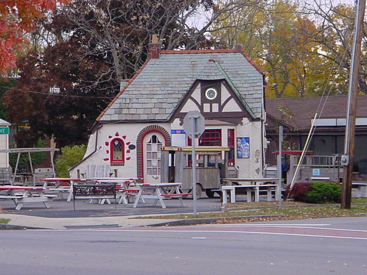
English: Photo of the former Liebler-Rohl Gasoline Station in Lancaster that is on the National Register of Historic Places. |
| Date | (UTC) |
| Source | I (Shinerunner (talk) ) created this work entirely by myself. |
| Author | Shinerunner (talk) |
| Object location | | View this and other nearby images on: OpenStreetMap |
|---|
Licensing
[edit]
Shinerunner at English Wikipedia, the copyright holder of this work, hereby publishes it under the following licenses:
This file is licensed under the Creative Commons Attribution-Share Alike 3.0 Unported license.
Attribution: Shinerunner at English Wikipedia
- You are free:
- to share – to copy, distribute and transmit the work
- to remix – to adapt the work
- Under the following conditions:
- attribution – You must give appropriate credit, provide a link to the license, and indicate if changes were made. You may do so in any reasonable manner, but not in any way that suggests the licensor endorses you or your use.
- share alike – If you remix, transform, or build upon the material, you must distribute your contributions under the same or compatible license as the original.

|
Permission is granted to copy, distribute and/or modify this document under the terms of the GNU Free Documentation License, Version 1.2 or any later version published by the Free Software Foundation; with no Invariant Sections, no Front-Cover Texts, and no Back-Cover Texts. A copy of the license is included in the section entitled GNU Free Documentation License. |
You may select the license of your choice.
Original upload log
[edit]
Transferred from en.wikipedia to Commons by Shinerunner using CommonsHelper.
The original description page was here. All following user names refer to en.wikipedia.
- 2009-10-22 23:31 Shinerunner 1472×1104× (707793 bytes) {{Information |Description = Photo of the former [[Liebler-Rohl Gasoline Station]] in [[Lancaster, New York]] that is on the [[National Register of Historic Places]]. |Source = I (~~~) created this work entirely by myself. |Date = ~~~~~ |Author = ~~~ |other_versions = }}
File history
Click on a date/time to view the file as it appeared at that time.
| Date/Time | Thumbnail | Dimensions | User | Comment | |
|---|---|---|---|---|---|
| current | 23:56, 28 October 2009 | | 1,472 × 1,104 (691 KB) | File Upload Bot (Magnus Manske) (talk | contribs) | {{BotMoveToCommons|en.wikipedia|year={{subst:CURRENTYEAR}}|month={{subst:CURRENTMONTHNAME}}|day={{subst:CURRENTDAY}}}} {{Information |Description={{en|Photo of the former en:Liebler-Rohl Gasoline Station in en:Lancaster, New York that is on t |
You cannot overwrite this file.
File usage on Commons
The following page uses this file:
File usage on other wikis
The following other wikis use this file:
- Usage on en.wikipedia.org
- Usage on fy.wikipedia.org
- Usage on www.wikidata.org
Metadata
Categories:
- Former gas stations in New York (state)
- Built in New York (state) in 1935
- Broadway Historic District (Lancaster, New York)
- Picnic tables in New York (state)
- 2009 in Erie County, New York
- October 2009 in New York (state)
- Buildings on the National Register of Historic Places in Erie County, New York
- Stucco buildings in Erie County, New York
- Tudor Revival architecture in Erie County, New York
- 1930s architecture in Erie County, New York
- Buildings in Lancaster (town), New York