File:Ligne A du métro de Rennes.svg
Jump to navigation
Jump to search

Size of this PNG preview of this SVG file: 772 × 599 pixels. Other resolutions: 309 × 240 pixels | 619 × 480 pixels | 990 × 768 pixels | 1,280 × 994 pixels | 2,560 × 1,987 pixels | 1,077 × 836 pixels.
Original file (SVG file, nominally 1,077 × 836 pixels, file size: 35 KB)
Captions
Captions
Add a one-line explanation of what this file represents
Summary[edit]
| Description |
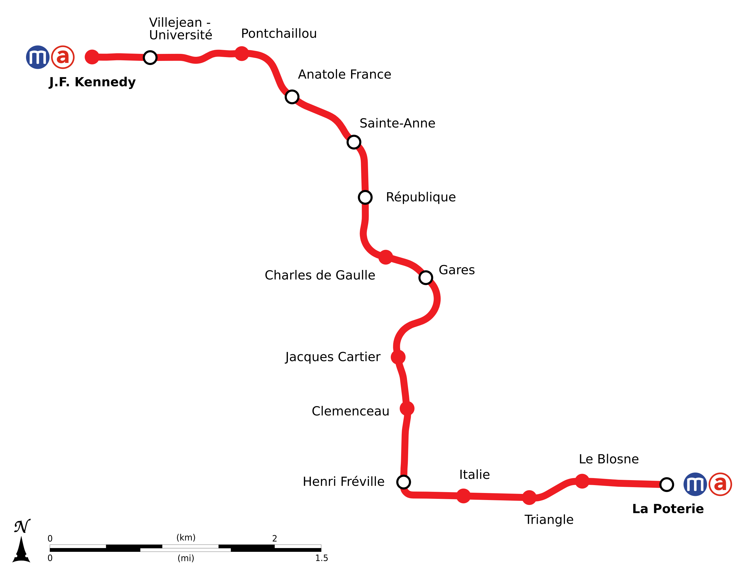
Français : Plan géographique de la ligne A du métro de Rennes. |
| Date | |
| Source | Own work from OpenStreetMap.org |
| Author | Flappiefh |
Licensing[edit]
I, the copyright holder of this work, hereby publish it under the following license:
This file is licensed under the Creative Commons Attribution-Share Alike 4.0 International license.
- You are free:
- to share – to copy, distribute and transmit the work
- to remix – to adapt the work
- Under the following conditions:
- attribution – You must give appropriate credit, provide a link to the license, and indicate if changes were made. You may do so in any reasonable manner, but not in any way that suggests the licensor endorses you or your use.
- share alike – If you remix, transform, or build upon the material, you must distribute your contributions under the same or compatible license as the original.
File history
Click on a date/time to view the file as it appeared at that time.
| Date/Time | Thumbnail | Dimensions | User | Comment | |
|---|---|---|---|---|---|
| current | 17:25, 26 December 2020 | | 1,077 × 836 (35 KB) | Lyon-St-Clair (talk | contribs) | Rendu du logo de la ligne amélioré. |
| 17:31, 11 October 2016 |  | 1,077 × 836 (34 KB) | Flappiefh (talk | contribs) | User created page with UploadWizard |
You cannot overwrite this file.
File usage on Commons
The following 11 pages use this file:
- User:Chumwa/OgreBot/München/2016 October 11-20
- User:Chumwa/OgreBot/Potential transport maps/2016 October 11-20
- User:Chumwa/OgreBot/Public transport information/2016 October 11-20
- User:Chumwa/OgreBot/Public transport information/2020 December 21-31
- User:Chumwa/OgreBot/Transport Maps/2016 October 11-20
- User:Chumwa/OgreBot/Transport Maps/2020 December 21-31
- User:Chumwa/OgreBot/Travel and communication maps/2016 October 11-20
- File:Rennes-Metro-Plan.png
- File:Rennes-Metro-Plan.svg
- Category:Rennes Metro
- Category:Rennes Metro Ligne A
File usage on other wikis
The following other wikis use this file:
- Usage on en.wikipedia.org
- Usage on es.wikipedia.org
- Usage on eu.wikipedia.org
- Usage on fa.wikipedia.org
- Usage on fr.wikipedia.org
- Usage on fur.wikipedia.org
- Usage on it.wikipedia.org
- Usage on oc.wikipedia.org
- Usage on www.wikidata.org