File:Linemap of Highway Buses in Niigata Prefecture.svg
Jump to navigation
Jump to search

Size of this PNG preview of this SVG file: 665 × 600 pixels. Other resolutions: 266 × 240 pixels | 532 × 480 pixels | 852 × 768 pixels | 1,135 × 1,024 pixels | 2,271 × 2,048 pixels | 2,387 × 2,153 pixels.
Original file (SVG file, nominally 2,387 × 2,153 pixels, file size: 2.76 MB)
Captions
Captions
Add a one-line explanation of what this file represents
Summary[edit]
| Description |
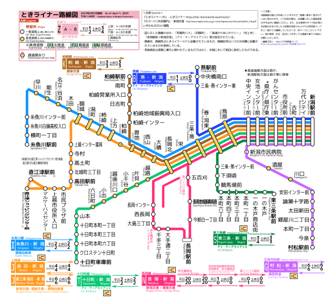
日本語: 新潟県・県内高速バス路線図(最終更新日は図内上部に表示)。県外線は別図参照。その他の図はカテゴリからご覧ください。
<出典(いずれも2022.6.2閲覧)>
<ご注意> <Inkscapeによる編集方法> 利用者:Hksn127を参照。 |
| Date | |
| Source | Own work |
| Author | Hksn127 |
Licensing[edit]
I, the copyright holder of this work, hereby publish it under the following license:
This file is licensed under the Creative Commons Attribution-Share Alike 4.0 International license.
- You are free:
- to share – to copy, distribute and transmit the work
- to remix – to adapt the work
- Under the following conditions:
- attribution – You must give appropriate credit, provide a link to the license, and indicate if changes were made. You may do so in any reasonable manner, but not in any way that suggests the licensor endorses you or your use.
- share alike – If you remix, transform, or build upon the material, you must distribute your contributions under the same or compatible license as the original.
File history
Click on a date/time to view the file as it appeared at that time.
| Date/Time | Thumbnail | Dimensions | User | Comment | |
|---|---|---|---|---|---|
| current | 03:46, 1 April 2023 | | 2,387 × 2,153 (2.76 MB) | Nlr0277 (talk | contribs) | baseの白が正しく反映されていなかったので修正 |
| 03:40, 1 April 2023 |  | 2,387 × 2,153 (2.5 MB) | Nlr0277 (talk | contribs) | Reverted to version as of 08:21, 5 July 2022 (UTC) | |
| 03:36, 1 April 2023 |  | 2,387 × 2,153 (3.22 MB) | Nlr0277 (talk | contribs) | 2023年4月改正に対応・路線色をHPで使用されているものに変更・出典変更 | |
| 08:21, 5 July 2022 |  | 2,387 × 2,153 (2.5 MB) | Nlr0277 (talk | contribs) | 上越線の本数に誤りがあったため修正・路線記号のパス化がされていない部分があったため修正 | |
| 13:51, 2 June 2022 |  | 2,387 × 2,153 (2.49 MB) | Nlr0277 (talk | contribs) | 「20224月1日現在」となっており「年」が抜けていたため修正 | |
| 08:39, 2 June 2022 |  | 2,387 × 2,153 (2.49 MB) | Nlr0277 (talk | contribs) | 巻潟東IC「停車場線」となっていたのを修正 | |
| 08:16, 2 June 2022 |  | 2,387 × 2,153 (2.48 MB) | Nlr0277 (talk | contribs) | Linemap_of_Highway_Buses_in_Niigata_Prefecture.svg | |
| 09:43, 6 April 2020 |  | 2,230 × 2,025 (2.18 MB) | Hksn127 (talk | contribs) | 2020.4.1版に更新 | |
| 10:01, 5 April 2019 |  | 2,230 × 2,025 (2.15 MB) | Hksn127 (talk | contribs) | 万代シテイの名称変更反映忘れ | |
| 09:14, 5 April 2019 |  | 2,230 × 2,025 (2.16 MB) | Hksn127 (talk | contribs) | 2019.4.1版に更新。 |
You cannot overwrite this file.
File usage on Commons
The following 28 pages use this file:
- User:Chumwa/OgreBot/Potential transport maps/2017 November 1-10
- User:Chumwa/OgreBot/Potential transport maps/2018 December 1-10
- User:Chumwa/OgreBot/Potential transport maps/2018 May 11-20
- User:Chumwa/OgreBot/Potential transport maps/2018 October 1-10
- User:Chumwa/OgreBot/Potential transport maps/2019 April 1-10
- User:Chumwa/OgreBot/Public transport information/2017 November 1-10
- User:Chumwa/OgreBot/Public transport information/2018 December 1-10
- User:Chumwa/OgreBot/Public transport information/2018 May 11-20
- User:Chumwa/OgreBot/Public transport information/2018 October 1-10
- User:Chumwa/OgreBot/Public transport information/2019 April 1-10
- User:Chumwa/OgreBot/Public transport information/2020 April 1-10
- User:Chumwa/OgreBot/Public transport information/2022 July 1-10
- User:Chumwa/OgreBot/Public transport information/2022 June 1-10
- User:Chumwa/OgreBot/Public transport information/2023 April 1-10
- User:Chumwa/OgreBot/Transport Maps/2017 November 1-10
- User:Chumwa/OgreBot/Transport Maps/2018 December 1-10
- User:Chumwa/OgreBot/Transport Maps/2018 May 11-20
- User:Chumwa/OgreBot/Transport Maps/2018 October 1-10
- User:Chumwa/OgreBot/Transport Maps/2019 April 1-10
- User:Chumwa/OgreBot/Transport Maps/2020 April 1-10
- User:Chumwa/OgreBot/Transport Maps/2022 July 1-10
- User:Chumwa/OgreBot/Transport Maps/2022 June 1-10
- User:Chumwa/OgreBot/Transport Maps/2023 April 1-10
- User:Chumwa/OgreBot/Travel and communication maps/2017 November 1-10
- User:Chumwa/OgreBot/Travel and communication maps/2018 December 1-10
- User:Chumwa/OgreBot/Travel and communication maps/2018 May 11-20
- User:Chumwa/OgreBot/Travel and communication maps/2018 October 1-10
- User:Chumwa/OgreBot/Travel and communication maps/2019 April 1-10
File usage on other wikis
The following other wikis use this file:
- Usage on de.wikivoyage.org
- Usage on en.wikipedia.org
- Usage on ja.wikipedia.org
- Usage on www.wikidata.org