File:LithuaniaCounties1918-1940.png
Jump to navigation
Jump to search

Size of this preview: 751 × 599 pixels. Other resolutions: 301 × 240 pixels | 602 × 480 pixels | 962 × 768 pixels | 1,280 × 1,022 pixels | 1,600 × 1,277 pixels.
Original file (1,600 × 1,277 pixels, file size: 582 KB, MIME type: image/png)
Captions
Captions
Add a one-line explanation of what this file represents
Summary[edit]
| Description |
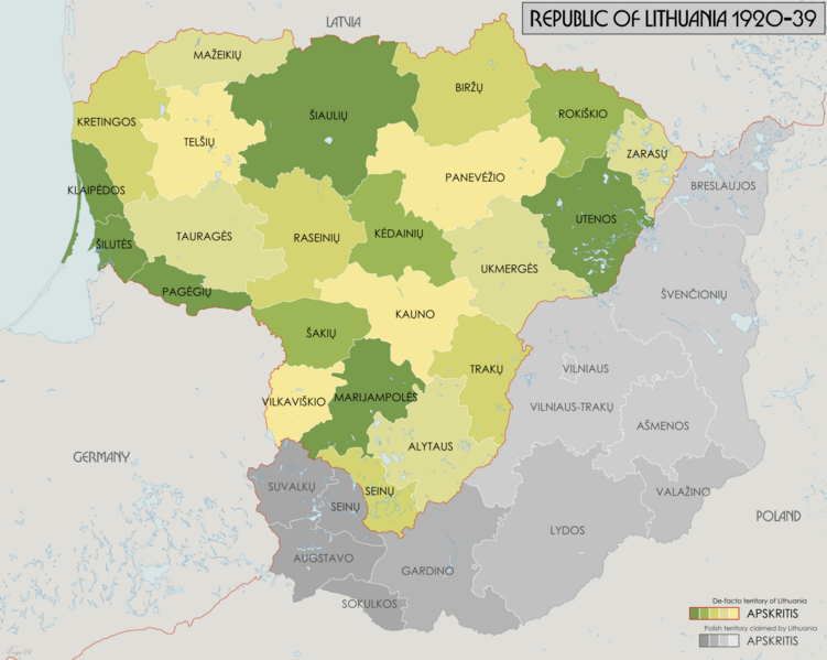
English: Administrative map of the counties of the Republic of Lithuania 1918-1940. Source data: "Badan Spraw Narodowosciowych" Jan 1919 (1:750k) courtesy of maps4u.lt. "Mapa Administracyjna Rzeczypospolitej Polskiej" (1:300k) courtesy of mapywig.org. |
| Date | |
| Source | Own work |
| Author | XrysD |
Licensing[edit]
I, the copyright holder of this work, hereby publish it under the following license:
This file is licensed under the Creative Commons Attribution-Share Alike 4.0 International license.
- You are free:
- to share – to copy, distribute and transmit the work
- to remix – to adapt the work
- Under the following conditions:
- attribution – You must give appropriate credit, provide a link to the license, and indicate if changes were made. You may do so in any reasonable manner, but not in any way that suggests the licensor endorses you or your use.
- share alike – If you remix, transform, or build upon the material, you must distribute your contributions under the same or compatible license as the original.
File history
Click on a date/time to view the file as it appeared at that time.
| Date/Time | Thumbnail | Dimensions | User | Comment | |
|---|---|---|---|---|---|
| current | 20:43, 27 November 2014 | | 1,600 × 1,277 (582 KB) | XrysD (talk | contribs) | Swapped labels of Klaipedos and Silutes. |
| 20:57, 3 November 2014 |  | 1,600 × 1,277 (581 KB) | XrysD (talk | contribs) | User created page with UploadWizard |
You cannot overwrite this file.
File usage on Commons
There are no pages that use this file.
File usage on other wikis
The following other wikis use this file:
- Usage on bn.wikipedia.org
- Usage on el.wikipedia.org
- Usage on en.wikipedia.org
- Usage on lt.wikipedia.org
- Lietuvos apskritys
- Kauno apskritis
- Lietuvos istorija (1918–1940)
- Šilutės apskritis
- Kretingos apskritis
- Biržų apskritis
- Kėdainių apskritis
- Pagėgių apskritis
- Mažeikių apskritis
- Raseinių apskritis
- Rokiškio apskritis
- Šakių apskritis
- Vilniaus-Trakų apskritis
- Ukmergės apskritis (1795–1950)
- Vilkaviškio apskritis
- Seinų apskritis (1919–1941)
- Telšių apskrities istorija
- Šiaulių apskrities istorija
- Panevėžio apskrities istorija
- Klaipėdos apskrities istorija
- Marijampolės apskrities istorija
- Šablonas:LT aps 1919-39
- Tauragės apskritis (1918–1950)
- Alytaus apskritis (1915–1950)
- Utenos apskritis (1915–1950)
- Vilniaus apskritis (1939–1950)
- Vilniaus apskritis (1919–1922)
- Kauno apskritis (1915–1950)
- Trakų apskritis (1919–1950)
- Breslaujos apskritis (1919–1939)
- Ašmenos apskritis (1920–1944)
- Švenčionių apskritis (1918–1950)
- Zarasų apskritis (1919–1950)
- Kauno apskritis (reikšmės)
- Trakų apskritis
- Ukmergės apskritis
- Zarasų apskritis
- Usage on lv.wikipedia.org