File:Litslebymannen 1.jpg
Jump to navigation
Jump to search
No higher resolution available.
Litslebymannen_1.jpg (768 × 512 pixels, file size: 145 KB, MIME type: image/jpeg)
Captions
Captions
Add a one-line explanation of what this file represents
Summary
[edit]| Litslebymannen
( |
|||||||||||||||||||||||||||
|---|---|---|---|---|---|---|---|---|---|---|---|---|---|---|---|---|---|---|---|---|---|---|---|---|---|---|---|
| Photographer |
Bengt A Lundberg |
||||||||||||||||||||||||||
| Title |
Litslebymannen |
||||||||||||||||||||||||||
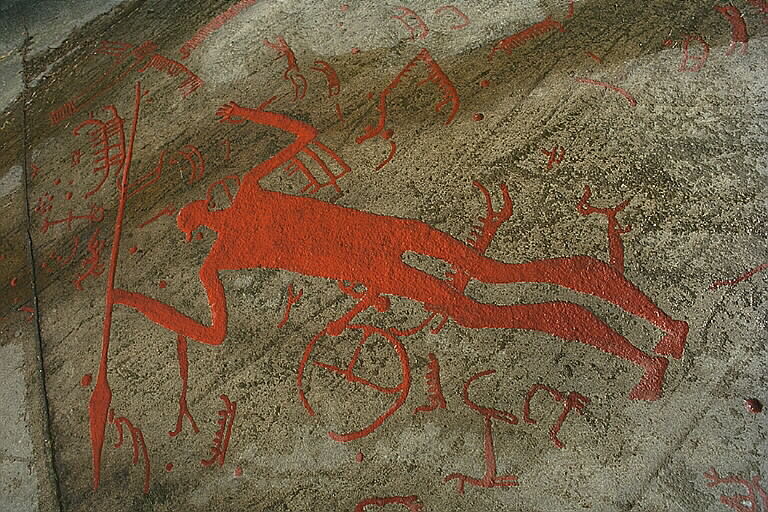
| Original caption |
Notera Av dokumentationsskäl har originalbeskrivningen från Riksantikvarieämbetet behållits. Tillrättalägganden och alternativa beskrivningar bör införas separat från nedanstående information. Övernaturligt stor människofigur,jägare med spjut. Skepp, djur och cirkelfigurer. Vattenöversilad häll. Tanum 75:1.Felaktigheter kan även anmälas till denna sida. |
||||||||||||||||||||||||||
| Description |
|
||||||||||||||||||||||||||
| Depicted place | County (län): Västra Götaland, Municipality (kommun): Tanum, Province (landskap): Bohuslän, Parish (socken): Tanum, Plats: Tanum | ||||||||||||||||||||||||||
| Date | 28 April 1997 | ||||||||||||||||||||||||||
| Collection |
|
||||||||||||||||||||||||||
| Accession number | |||||||||||||||||||||||||||
| Source | Kulturmiljöbild, Riksantikvarieämbetet | ||||||||||||||||||||||||||
| Permission (Reusing this file) |
|
||||||||||||||||||||||||||


| Object location | | View this and other nearby images on: OpenStreetMap |
|---|
File history
Click on a date/time to view the file as it appeared at that time.
| Date/Time | Thumbnail | Dimensions | User | Comment | |
|---|---|---|---|---|---|
| current | 17:53, 1 September 2012 | | 768 × 512 (145 KB) | Lavallen (talk | contribs) | {{Information |Description={{sv|Litslebymannen {{fornminne|10160600750001|raä-nr=Tanum 75:1}}}} |Source={{KMB-link|16000300019271}} |Date=1997-04-28 |Author=Bengt A Lundberg, Riksantikvarieämbetet |Permission={{CC-BY|Bengt A Lundberg, Riksantikvarie... |
You cannot overwrite this file.
File usage on Commons
The following 2 pages use this file:
File usage on other wikis
The following other wikis use this file:
- Usage on sv.wikipedia.org
- Usage on www.wikidata.org