File:Localizzazione Forche Caudine.svg
Jump to navigation
Jump to search

Size of this PNG preview of this SVG file: 800 × 443 pixels. Other resolutions: 320 × 177 pixels | 640 × 354 pixels | 1,024 × 567 pixels | 1,280 × 709 pixels | 2,560 × 1,418 pixels | 2,602 × 1,441 pixels.
Original file (SVG file, nominally 2,602 × 1,441 pixels, file size: 4.15 MB)
Captions
Captions
Add a one-line explanation of what this file represents
Summary[edit]
| Description |
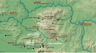
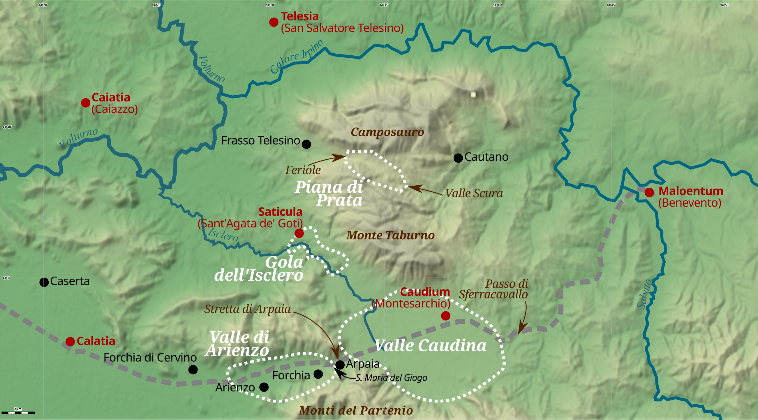
Italiano: Mappa delle possibili collocazioni della battaglia delle Forche Caudine. Lo sfondo è stato realizzato con Maperitive, il corso dei fiumi è quello delle mappe di OpenStreetMap. I centri abitati dell'epoca sono in rosso (quando compare anche un nome odierno, l'identificazione può essere approssimativa); quelli attuali sono in nero. La futura Via Appia romana è disegnata in grigio tratteggiato. |
| Date | |
| Source | Own work |
| Author | Decan |
Licensing[edit]
I, the copyright holder of this work, hereby publish it under the following licenses:
This file is licensed under the Creative Commons Attribution-Share Alike 3.0 Unported license.
- You are free:
- to share – to copy, distribute and transmit the work
- to remix – to adapt the work
- Under the following conditions:
- attribution – You must give appropriate credit, provide a link to the license, and indicate if changes were made. You may do so in any reasonable manner, but not in any way that suggests the licensor endorses you or your use.
- share alike – If you remix, transform, or build upon the material, you must distribute your contributions under the same or compatible license as the original.

|
Permission is granted to copy, distribute and/or modify this document under the terms of the GNU Free Documentation License, Version 1.2 or any later version published by the Free Software Foundation; with no Invariant Sections, no Front-Cover Texts, and no Back-Cover Texts. A copy of the license is included in the section entitled GNU Free Documentation License. |
You may select the license of your choice.
File history
Click on a date/time to view the file as it appeared at that time.
| Date/Time | Thumbnail | Dimensions | User | Comment | |
|---|---|---|---|---|---|
| current | 12:45, 31 July 2016 | | 2,602 × 1,441 (4.15 MB) | Decan (talk | contribs) | Minor changes in label placement; removed a wrong hypothesis |
| 17:18, 2 February 2014 |  | 2,602 × 1,441 (4.16 MB) | Decan (talk | contribs) | Better placement of labels | |
| 17:16, 2 February 2014 |  | 2,602 × 1,441 (4.16 MB) | Decan (talk | contribs) | {{Information |Description ={{it|1=Mappa delle possibili collocazioni della battaglia delle Forche Caudine. Lo sfondo è stato realizzato con Maperitive, il corso dei fiumi è quello delle mappe di OpenStreetMap.}} |Source ={{own}} |Author... |
You cannot overwrite this file.
File usage on Commons
There are no pages that use this file.
File usage on other wikis
The following other wikis use this file:
- Usage on es.wikipedia.org
- Usage on it.wikipedia.org