File:LocationSeychellesOuterIslands.PNG
Jump to navigation
Jump to search
No higher resolution available.
LocationSeychellesOuterIslands.PNG (250 × 119 pixels, file size: 5 KB, MIME type: image/png)
Captions
Captions
Add a one-line explanation of what this file represents
Summary[edit]
| Description |
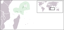
English: Location map of the Outer Seychelles Islands (Coralline Seychelles) coral archipelago of the Seychelles islands and nation.
|
| Date | |
| Source | Own work |
| Author | Telim tor |
Licensing[edit]
| I, the copyright holder of this work, release this work into the public domain. This applies worldwide. In some countries this may not be legally possible; if so: I grant anyone the right to use this work for any purpose, without any conditions, unless such conditions are required by law. |
File history
Click on a date/time to view the file as it appeared at that time.
| Date/Time | Thumbnail | Dimensions | User | Comment | |
|---|---|---|---|---|---|
| current | 11:23, 19 April 2010 | | 250 × 119 (5 KB) | Telim tor (talk | contribs) | == {{int:filedesc}} == {{Information |Description=Location of the Outer Islands of Seychelles |Source={{own}} |Date=2010-04-19 |Author=Telim tor |Permission= |other_versions= }} == {{int:license}} == {{PD-self}} [[Category:Maps of Sey |
| 11:23, 19 April 2010 |  | 250 × 119 (5 KB) | Telim tor (talk | contribs) | == {{int:filedesc}} == {{Information |Description=Location of the Outer Islands of Seychelles |Source={{own}} |Date=2010-04-19 |Author=Telim tor |Permission= |other_versions= }} == {{int:license}} == {{PD-self}} [[Category:Maps of Sey |
You cannot overwrite this file.
File usage on Commons
There are no pages that use this file.
File usage on other wikis
The following other wikis use this file:
- Usage on nl.wikipedia.org
- Usage on ru.wikipedia.org