File:Location map Syria Old Damascus.png
Jump to navigation
Jump to search

Size of this preview: 566 × 599 pixels. Other resolutions: 227 × 240 pixels | 453 × 480 pixels | 896 × 949 pixels.
Original file (896 × 949 pixels, file size: 520 KB, MIME type: image/png)
Captions
Captions
Add a one-line explanation of what this file represents
| Description |
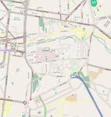
English: Map of Old Damascus
Geographic limits of the map:
This file is licensed under the Creative Commons Attribution-Share Alike 2.0 Generic license.
|
| Date | |
| Source | OpenStreetMap |
| Author | Dr. Blofeld |
File history
Click on a date/time to view the file as it appeared at that time.
| Date/Time | Thumbnail | Dimensions | User | Comment | |
|---|---|---|---|---|---|
| current | 12:50, 28 February 2011 | | 896 × 949 (520 KB) | Blofeld Dr. (talk | contribs) | {{Information |Description ={{en|1=t}} |Source =t |Author =t |Date =t |Permission = |other_versions = }} |
You cannot overwrite this file.
File usage on Commons
There are no pages that use this file.
File usage on other wikis
The following other wikis use this file:
- Usage on ar.wikipedia.org
- Usage on av.wikipedia.org
- Usage on bn.wikipedia.org
- Usage on ceb.wikipedia.org
- Usage on el.wikipedia.org
- Usage on en.wikipedia.org
- Usage on fa.wikipedia.org
- Usage on fr.wikipedia.org
- Usage on id.wikipedia.org
- Usage on ja.wikipedia.org
- Usage on kn.wikipedia.org
- Usage on ms.wikipedia.org
- Usage on pa.wikipedia.org
- Usage on si.wikipedia.org
- Usage on tr.wikipedia.org
- Usage on ur.wikipedia.org
- Usage on uz.wikipedia.org
- Usage on war.wikipedia.org
- Usage on zh.wikipedia.org