File:Londesborough Park - geograph.org.uk - 589094.jpg
Londesborough_Park_-_geograph.org.uk_-_589094.jpg (640 × 473 pixels, file size: 89 KB, MIME type: image/jpeg)
Captions
Captions
Summary[edit]
| Description |
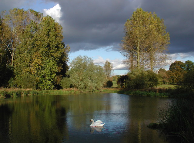
English: Londesborough Park, Londesborough, East Riding of Yorkshire, England. Evening sun on the pond northeast of Londesborough Park Lake, looking east-northeast from the footbridge across the disused ford on the old Wolds Way long distance route between Londesborough and Goodmanham. The house at Londesborough was demolished in 1819 by the 6th Duke of Devonshire, who under mounting financial strain sold the estate in 1845 to George Hudson "The Railway King". Hudson intended to live here and build a railway from York to Market Weighton with his own private station at Shiptonthorpe. He had a two-mile avenue of trees planted between the railway and the park but then things started to go wrong. "The King" ran into financial difficulties with the collapse of the over-inflated railway share price and was accused of corruption, bribing MPs and selling land he did not own. He left Londesborough in disgrace and was imprisoned in York Castle for debt in 1865. The original Wolds Way long distance footpath was established in 1982 and covered 76 miles from the Humber Bridge at Hessle to Filey Brigg on the North Sea coast. The route headed southeast through Londesborough Park and across the old ford here on the park lake before heading down to Goodmanham. The route was largely superseded by the 79-mile Yorkshire Wolds Way in 2003, the main course of which now heads due south from Londesborough along Towthorpe Beck to the western outskirts of Market Weighton. |
| Date | |
| Source | From geograph.org.uk |
| Author | Paul Glazzard |
| Permission (Reusing this file) |
Creative Commons Attribution Share-alike license 2.0 |
| Other versions |
|
| Attribution (required by the license) | Paul Glazzard / Londesborough Park / |

| Camera location | | View this and other nearby images on: OpenStreetMap |
|---|
_heading:67.00&language=en)
| Object location | | View this and other nearby images on: OpenStreetMap |
|---|
_heading:67.00&language=en)
Licensing[edit]

|
This image was taken from the Geograph project collection. See this photograph's page on the Geograph website for the photographer's contact details. The copyright on this image is owned by Paul Glazzard and is licensed for reuse under the Creative Commons Attribution-ShareAlike 2.0 license.
|
- You are free:
- to share – to copy, distribute and transmit the work
- to remix – to adapt the work
- Under the following conditions:
- attribution – You must give appropriate credit, provide a link to the license, and indicate if changes were made. You may do so in any reasonable manner, but not in any way that suggests the licensor endorses you or your use.
- share alike – If you remix, transform, or build upon the material, you must distribute your contributions under the same or compatible license as the original.
File history
Click on a date/time to view the file as it appeared at that time.
| Date/Time | Thumbnail | Dimensions | User | Comment | |
|---|---|---|---|---|---|
| current | 14:20, 6 February 2011 | | 640 × 473 (89 KB) | GeographBot (talk | contribs) | == {{int:filedesc}} == {{Information |description={{en|1=Londesborough Park Evening sun on the pond northeast of Londesborough Park Lake, looking east-northeast from the footbridge across the disused ford on the old Wolds Way long distance route between L |
You cannot overwrite this file.
File usage on Commons
The following page uses this file:
File usage on other wikis
The following other wikis use this file:
- Usage on dag.wikipedia.org
- Usage on en.wikipedia.org