File:Long Beach Street Circuit IndyCar.svg
Jump to navigation
Jump to search

Size of this PNG preview of this SVG file: 800 × 568 pixels. Other resolutions: 320 × 227 pixels | 640 × 454 pixels | 1,024 × 726 pixels | 1,280 × 908 pixels | 2,560 × 1,816 pixels | 1,397 × 991 pixels.
Original file (SVG file, nominally 1,397 × 991 pixels, file size: 89 KB)
Captions
Captions
Add a one-line explanation of what this file represents
Summary[edit]
| Description |
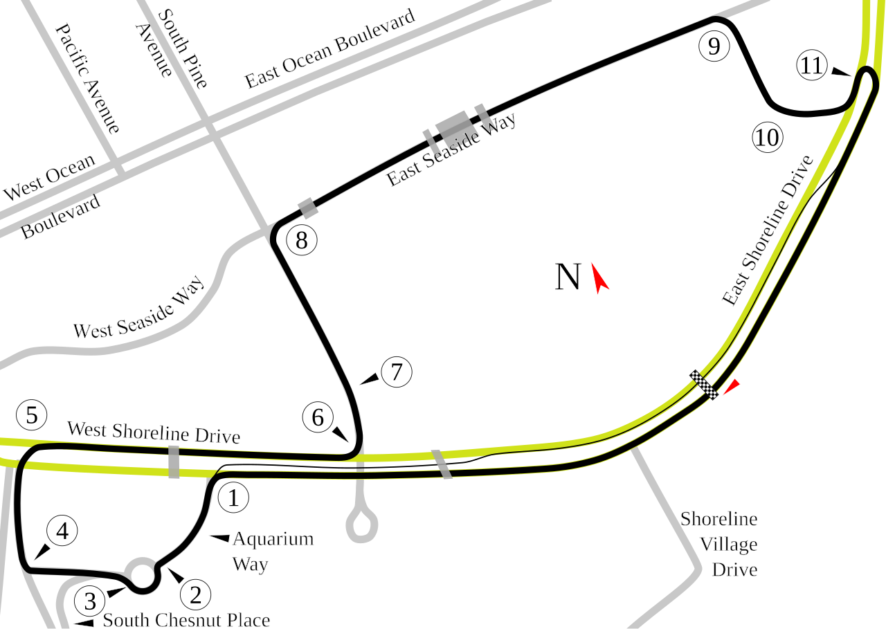
English: Track map of the Long Beach Street Racing Circuit. The yellow and gray lines are the local streets for reference. The gray transparent blocks over the streets and course are overpasses that interfere with the transmissions from the race cars. |
| Source | Own work |
| Author | Will Pittenger |
| Camera location | | View this and other nearby images on: OpenStreetMap |
|---|
Licensing[edit]
| I, the copyright holder of this work, release this work into the public domain. This applies worldwide. In some countries this may not be legally possible; if so: I grant anyone the right to use this work for any purpose, without any conditions, unless such conditions are required by law. |
File history
Click on a date/time to view the file as it appeared at that time.
| Date/Time | Thumbnail | Dimensions | User | Comment | |
|---|---|---|---|---|---|
| current | 07:59, 19 July 2008 | | 1,397 × 991 (89 KB) | Will Pittenger (talk | contribs) | New version gets around Mediawiki/RSVG's problem with Text on paths (the text is hidden) by converting that text into paths. If you need to edit the file, please use the old version. |
| 07:07, 19 July 2008 |  | 1,397 × 991 (67 KB) | Will Pittenger (talk | contribs) | {{Information |Description={{en|1=Track map of the Long Beach Street Racing Circuit. The yellow and gray lines are the local streets for reference. The gray transparent blocks over the streets and course are overpasses that i |
You cannot overwrite this file.
File usage on Commons
The following 6 pages use this file:
File usage on other wikis
The following other wikis use this file:
- Usage on ast.wikipedia.org
- Usage on bg.wikipedia.org
- Usage on de.wikipedia.org
- Long Beach Grand Prix Circuit
- Liste der IndyCar/ChampCar-Rennstrecken
- Toyota Grand Prix of Long Beach 2012
- Toyota Grand Prix of Long Beach 2013
- Toyota Grand Prix of Long Beach 2014
- Toyota Grand Prix of Long Beach 2015
- Grand Prix of Long Beach 2022
- Kategorie:Long Beach Grand Prix Circuit
- Grand Prix of Long Beach 2023
- Grand Prix of Long Beach 2021
- Grand Prix of Long Beach 2024
- Usage on en.wikipedia.org
- Grand Prix of Long Beach
- Toyota Pro/Celebrity Race
- 2006 Toyota Grand Prix of Long Beach
- List of Champ Car circuits
- 2007 Toyota Grand Prix of Long Beach
- 2005 Toyota Grand Prix of Long Beach
- User talk:Chubbennaitor/archive2
- 2004 Toyota Grand Prix of Long Beach
- User talk:Barkjon/Archive 2
- 2008 American Le Mans Series at Long Beach
- 2003 Toyota Grand Prix of Long Beach
- Wikipedia:WikiProject Formula One/Newsletter/200808
- User talk:Hellboy2hell/archive2
- User talk:NapHit/Archive 1
- User talk:4u1e/archive5
- 2008 Toyota Grand Prix of Long Beach
- User talk:Typ932/Archive 3
- User talk:Midgrid/Archive 6
- User talk:Thelb4/Archive 5
- User talk:Chubbennaitor/Archive7
- User talk:Readro/Archive 3
- User talk:Donnie Park/Archive 1
- 2009 American Le Mans Series at Long Beach
- 2009 Toyota Grand Prix of Long Beach
- User talk:The359/Archive 4
- 2002 Toyota Grand Prix of Long Beach
- List of American Le Mans Series circuits
- User talk:Cs-wolves/Archive 3
- User talk:Bam123456789/Archive 1
- 2010 American Le Mans Series at Long Beach
- 2010 Toyota Grand Prix of Long Beach
- List of IndyCar Series racetracks
- 2011 American Le Mans Series at Long Beach
- 2011 Toyota Grand Prix of Long Beach
- 2012 American Le Mans Series at Long Beach
- 2012 Toyota Grand Prix of Long Beach
- 2007 Toyota Grand Prix of Long Beach (American Le Mans Series race)
View more global usage of this file.