File:Lower Coire na Sleaghaich on Slioch - geograph.org.uk - 66400.jpg
Jump to navigation
Jump to search
No higher resolution available.
Lower_Coire_na_Sleaghaich_on_Slioch_-_geograph.org.uk_-_66400.jpg (640 × 480 pixels, file size: 81 KB, MIME type: image/jpeg)
Captions
Captions
Add a one-line explanation of what this file represents
Summary[edit]
| Description |
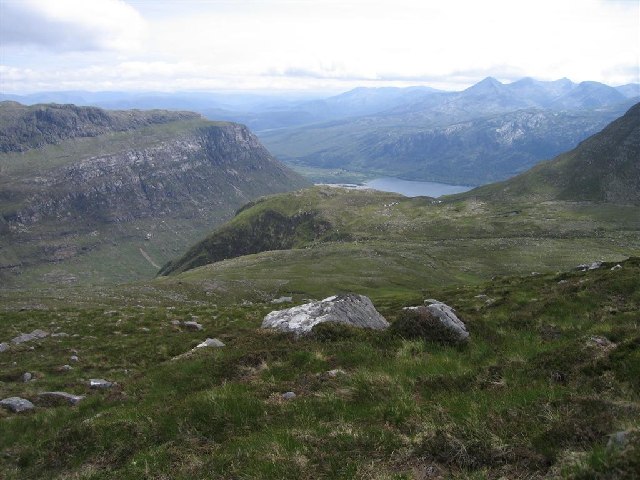
English: Lower Coire na Sleaghaich on Slioch. This rough grassy area lies in the inner confines of Slioch and its satellite tops, above Gleinn Bianasdail, which can be reached via a very steep descent down the gap seen in the centre of the photo.The steep slopes on the right are part of Sgurr Dubh. The bump in the centre is Meall Each. The photo was taken at 15:25 on 26th June, 2005. |
| Date | |
| Source | From geograph.org.uk |
| Author | David Crocker |
| Attribution (required by the license) | David Crocker / Lower Coire na Sleaghaich on Slioch / |
| Camera location | | View this and other nearby images on: OpenStreetMap |
|---|
_heading:202.00&language=en)
| Object location | | View this and other nearby images on: OpenStreetMap |
|---|
_heading:202.00&language=en)
Licensing[edit]

|
This image was taken from the Geograph project collection. See this photograph's page on the Geograph website for the photographer's contact details. The copyright on this image is owned by David Crocker and is licensed for reuse under the Creative Commons Attribution-ShareAlike 2.0 license.
|
This file is licensed under the Creative Commons Attribution-Share Alike 2.0 Generic license.
Attribution: David Crocker
- You are free:
- to share – to copy, distribute and transmit the work
- to remix – to adapt the work
- Under the following conditions:
- attribution – You must give appropriate credit, provide a link to the license, and indicate if changes were made. You may do so in any reasonable manner, but not in any way that suggests the licensor endorses you or your use.
- share alike – If you remix, transform, or build upon the material, you must distribute your contributions under the same or compatible license as the original.
File history
Click on a date/time to view the file as it appeared at that time.
| Date/Time | Thumbnail | Dimensions | User | Comment | |
|---|---|---|---|---|---|
| current | 16:48, 30 January 2010 | | 640 × 480 (81 KB) | GeographBot (talk | contribs) | == {{int:filedesc}} == {{Information |description={{en|1=Lower Coire na Sleaghaich on Slioch. This rough grassy area lies in the inner confines of Slioch and its satellite tops, above Gleinn Bianasdail, which can be reached via a very steep descent down t |
You cannot overwrite this file.
File usage on Commons
There are no pages that use this file.
File usage on other wikis
The following other wikis use this file:
- Usage on de.wikipedia.org