File:MESPLEDE altitude RGE-1m.png
Jump to navigation
Jump to search

Size of this preview: 506 × 600 pixels. Other resolutions: 202 × 240 pixels | 405 × 480 pixels | 648 × 768 pixels | 864 × 1,024 pixels | 2,291 × 2,716 pixels.
Original file (2,291 × 2,716 pixels, file size: 5.43 MB, MIME type: image/png)
Captions
Captions
Add a one-line explanation of what this file represents
Summary[edit]
| Description |
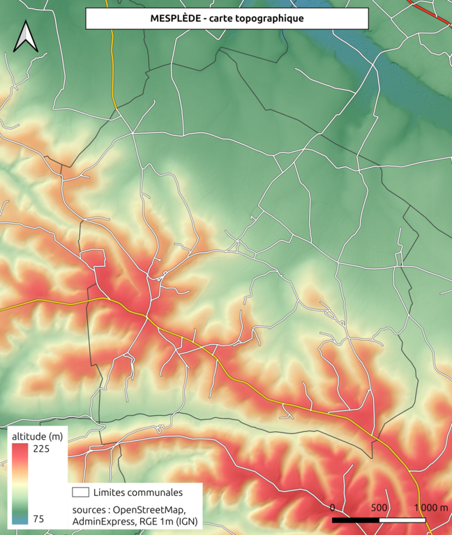
Français : Carte topographique de la commune de Mesplède, d'après le modèle numérique de terrain "RGE" (référentiel à grande échelle) au pas de 1 m de l'IGN (version 2021).
Les limites communales sont issues d'AdminExpress (IGN). Les routes sont issues d'OpenStreetMap. |
| Date | |
| Source | Own work |
| Author | BotaFlo |
Licensing[edit]
I, the copyright holder of this work, hereby publish it under the following license:
| This file is made available under the Creative Commons CC0 1.0 Universal Public Domain Dedication. | |
| The person who associated a work with this deed has dedicated the work to the public domain by waiving all of their rights to the work worldwide under copyright law, including all related and neighboring rights, to the extent allowed by law. You can copy, modify, distribute and perform the work, even for commercial purposes, all without asking permission.
|
File history
Click on a date/time to view the file as it appeared at that time.
| Date/Time | Thumbnail | Dimensions | User | Comment | |
|---|---|---|---|---|---|
| current | 09:58, 1 December 2023 | | 2,291 × 2,716 (5.43 MB) | BotaFlo (talk | contribs) | Uploaded own work with UploadWizard |
You cannot overwrite this file.
File usage on Commons
The following page uses this file:
File usage on other wikis
The following other wikis use this file:
- Usage on fr.wikipedia.org