File:MS804 flight path 2 de.svg
Jump to navigation
Jump to search

Size of this PNG preview of this SVG file: 700 × 599 pixels. Other resolutions: 280 × 240 pixels | 561 × 480 pixels | 897 × 768 pixels | 1,196 × 1,024 pixels | 2,392 × 2,048 pixels | 799 × 684 pixels.
Original file (SVG file, nominally 799 × 684 pixels, file size: 461 KB)
Captions
Captions
Add a one-line explanation of what this file represents
Summary[edit]
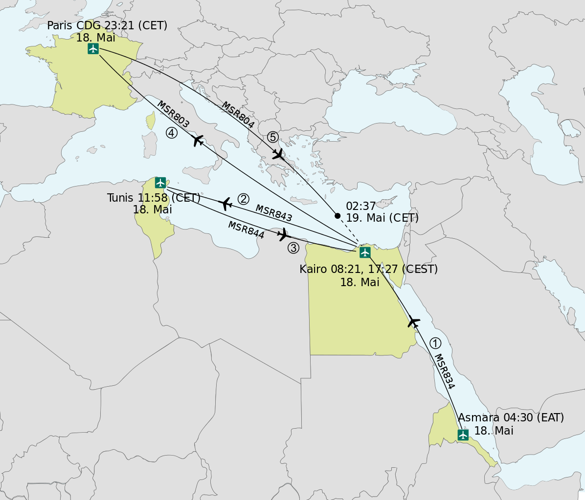
| Description |
Deutsch: Flugrouten von EgyptAir Flug 804. Alle Zeitangaben sind Abflugzeiten in mitteleuropäischer Sommerzeit
English: Flight path of EgyptAir Flight 804. All departure times are given in Central European summer time (UTC+2). |
||
| Date | |||
| Source |
|
||
| Author | Furfur | ||
| Permission (Reusing this file) |
I, the copyright holder of this work, hereby publish it under the following licenses:
This file is licensed under the Creative Commons Attribution-Share Alike 4.0 International license.
You may select the license of your choice. |
||
| SVG development | This vector image was created with Adobe Illustrator. |

File history
Click on a date/time to view the file as it appeared at that time.
| Date/Time | Thumbnail | Dimensions | User | Comment | |
|---|---|---|---|---|---|
| current | 08:46, 17 June 2016 | | 799 × 684 (461 KB) | Furfur (talk | contribs) | Detail |
| 08:38, 17 June 2016 |  | 799 × 684 (461 KB) | Furfur (talk | contribs) | new version according to suggestings by Bestoernesto | |
| 23:14, 19 May 2016 |  | 799 × 684 (461 KB) | Furfur (talk | contribs) | == {{int:filedesc}} == {{Information |Description={{User:Medium69/Traduction}} {{de|1=Flugrouten von EgyptAir Flug 804. Alle Zeitangaben sind Abflugzeiten in mitteleuropäischer Sommerzeit}} {{en|1=Flight path of EgyptAir Flight 804. All departure time... |
You cannot overwrite this file.
File usage on Commons
The following 3 pages use this file:
File usage on other wikis
The following other wikis use this file:
- Usage on de.wikipedia.org
- Usage on sv.wikipedia.org