File:Maatsuyker Islands.jpg
Jump to navigation
Jump to search
No higher resolution available.
Maatsuyker_Islands.jpg (640 × 480 pixels, file size: 39 KB, MIME type: image/jpeg)
Captions
Captions
Add a one-line explanation of what this file represents
Summary[edit]
| Description |
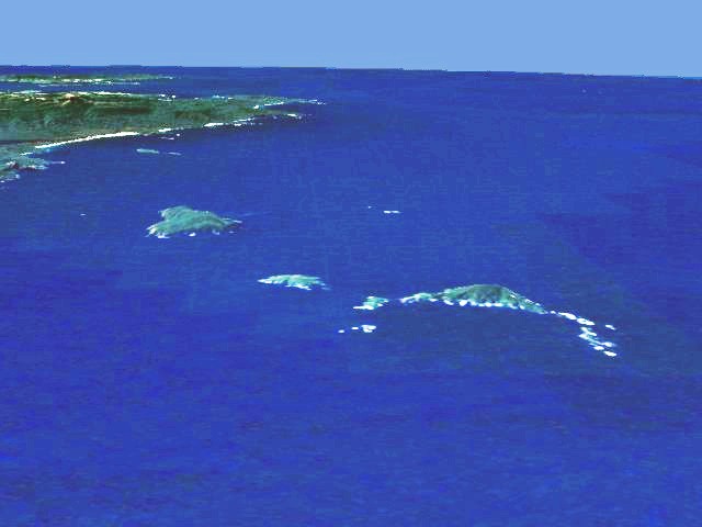
English: Aerial view of the southern coast of Tasmania. In the background South East Cape, in the foreground the Maatsuyker Islands (Needle Rocks are on the right; just to the left of them is Maatsuyker Island; De Witt is the larger island on the left). Artificial view generated from satellite data. |
| Date | 22 July 2006 (original upload date) |
| Source | Transferred from en.wikipedia to Commons. |
| Author | The original uploader was Phaedrus86 at English Wikipedia. |
| Permission (Reusing this file) |
I extracted this image from en:NASA World Wind, which makes it public domain because of US Government policies. It is an artificial view generated from satellite data. --Phaedrus86 03:21, 22 July 2006 (UTC) |
Licensing[edit]
| This image is in the public domain because it is a screenshot from NASA’s globe software World Wind using a public domain layer, such as Blue Marble, MODIS, Landsat, SRTM, USGS or GLOBE.
|
 |
Original upload log[edit]
The original description page was here. All following user names refer to en.wikipedia.
- 2006-07-22 03:20 Phaedrus86 640×480×8 (16889 bytes) I extracted this image from [[Nasa Worldwind]]. It is an artificial view generated from satellite data.
File history
Click on a date/time to view the file as it appeared at that time.
| Date/Time | Thumbnail | Dimensions | User | Comment | |
|---|---|---|---|---|---|
| current | 07:30, 1 April 2007 | | 640 × 480 (39 KB) | Ibn Battuta (talk | contribs) | edited to increase contrast and hence visibility |
| 04:19, 1 April 2007 |  | 640 × 480 (16 KB) | Ibn Battuta (talk | contribs) | {{Information |Description=Aerial view of the southern coast of Tasmania. In the background South East Cape, in the foreground the Maatsuyker Islands (Needle Rocks are on the right; just to the left of th |
You cannot overwrite this file.
File usage on Commons
The following page uses this file:
File usage on other wikis
The following other wikis use this file:
- Usage on ceb.wikipedia.org
- Usage on de.wikipedia.org
- Usage on en.wikipedia.org
- Usage on eo.wikipedia.org
- Usage on it.wikipedia.org
- Usage on nl.wikipedia.org
- Usage on ru.wikipedia.org
- Usage on uk.wikipedia.org
- Usage on www.wikidata.org