File:Malacca Sultanate zh-hans.svg

From Wikimedia Commons, the free media repository
Jump to navigation Jump to search

Original file(SVG file, nominally 512 × 581 pixels, file size: 364 KB)

Captions

Captions

Add a one-line explanation of what this file represents

Summary[edit]

Description
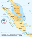
中文(中国大陆):马六甲苏丹国(Malacca Sultanate, 1402—1511)疆域,包括马来半岛及苏门答腊东海岸。基于《Atlas Sejarah Indonesia dan Dunia》绘制。
English: The historical map of Malacca Sultanate (1402–1511) Malay Peninsula and East Coast of Sumatra. Made and improved based on "Atlas Sejarah Indonesia dan Dunia" (The Atlas of Indonesian and World History), PT Pembina Peraga Jakarta 1996.
Date
Source

This file was derived from: Malacca Sultanate en.svg

中文译名参考文献:

  • 王任叔《印度尼西亚古代史》
  • 《古代南海地名汇释》
  • 《世界地名翻译大辞典》
Author Gunawan Kartapranata, translated by Buernia.
Other versions

[edit]

Licensing[edit]

w:en:Creative Commons
attribution share alike
This file is licensed under the Creative Commons Attribution-Share Alike 3.0 Unported license.
You are free:
  • to share – to copy, distribute and transmit the work
  • to remix – to adapt the work
Under the following conditions:
  • attribution – You must give appropriate credit, provide a link to the license, and indicate if changes were made. You may do so in any reasonable manner, but not in any way that suggests the licensor endorses you or your use.
  • share alike – If you remix, transform, or build upon the material, you must distribute your contributions under the same or compatible license as the original.

File history

Click on a date/time to view the file as it appeared at that time.

Date/TimeThumbnailDimensionsUserComment
current09:01, 9 August 2019Thumbnail for version as of 09:01, 9 August 2019512 × 581 (364 KB)Buernia (talk | contribs)User created page with UploadWizard

File usage on other wikis

The following other wikis use this file:

Metadata