File:Manchester Wards Map (Blank).svg
Jump to navigation
Jump to search

Size of this PNG preview of this SVG file: 330 × 599 pixels. Other resolutions: 132 × 240 pixels | 264 × 480 pixels | 423 × 768 pixels | 564 × 1,024 pixels | 1,128 × 2,048 pixels | 512 × 929 pixels.
Original file (SVG file, nominally 512 × 929 pixels, file size: 63 KB)
Captions
Captions
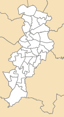
blank map displaying all electoral wards in Manchester
Summary[edit]
.svg&action=edit§ion=1)
| Description |
English: A blank map displaying all electoral wards in Manchester, updated for post-2018 boundaries. |
| Date | |
| Source |
Local Authority Boundaries: https://geoportal.statistics.gov.uk/search?collection=Dataset&sort=name&tags=all(BDY_CTYUA%2CDEC_2021) Ward Boundaries: https://geoportal.statistics.gov.uk/maps/wards-december-2021-gb-bgc Source: Office for National Statistics licensed under the Open Government Licence v.3.0 Contains OS data © Crown copyright and database right [2022] |
| Author | User:George.J.M01, created using Ordnance Survey data |
Licensing[edit]
.svg&action=edit§ion=2)
| I, the copyright holder of this work, release this work into the public domain. This applies worldwide. In some countries this may not be legally possible; if so: I grant anyone the right to use this work for any purpose, without any conditions, unless such conditions are required by law. |
File history
Click on a date/time to view the file as it appeared at that time.
| Date/Time | Thumbnail | Dimensions | User | Comment | |
|---|---|---|---|---|---|
| current | 04:05, 11 May 2022 | | 512 × 929 (63 KB) | George.J.M01 (talk | contribs) | Uploaded a work by User:George.J.M01George.J.M01, created using Ordnance Survey data from Local Authority Boundaries: https://geoportal.statistics.gov.uk/search?collection=Dataset&sort=name&tags=all(BDY_CTYUA%2CDEC_2021) Manchester Ward Boundaries: https://geoportal.statistics.gov.uk/maps/wards-december-2021-gb-bgc Source: Office for National Statistics licensed under the Open Government Licence v.3.0 Contains OS data © Crown copyright and database right [2022] with UploadWizard |
You cannot overwrite this file.
File usage on Commons
There are no pages that use this file.
.svg&oldid=666387320)