File:Map–Georgia and surroundings, 14-15th c.–en.svg
Jump to navigation
Jump to search

Size of this PNG preview of this SVG file: 800 × 546 pixels. Other resolutions: 320 × 218 pixels | 640 × 437 pixels | 1,024 × 699 pixels | 1,280 × 873 pixels | 2,560 × 1,747 pixels | 850 × 580 pixels.
Original file (SVG file, nominally 850 × 580 pixels, file size: 976 KB)
Captions
Captions
Add a one-line explanation of what this file represents
Summary[edit]
| Description |
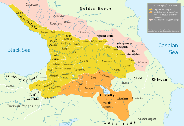
English: Kingdom of Georgia in Caucasus at the end of 14th and the beginning of 15th centuries. Its loss due to Tamerlane's invasions. |
| Date | |
| Source |
Own work |
| Author | Ercwlff |
Licensing[edit]
I, the copyright holder of this work, hereby publish it under the following license:
This file is licensed under the Creative Commons Attribution-Share Alike 4.0 International license.
- You are free:
- to share – to copy, distribute and transmit the work
- to remix – to adapt the work
- Under the following conditions:
- attribution – You must give appropriate credit, provide a link to the license, and indicate if changes were made. You may do so in any reasonable manner, but not in any way that suggests the licensor endorses you or your use.
- share alike – If you remix, transform, or build upon the material, you must distribute your contributions under the same or compatible license as the original.
File history
Click on a date/time to view the file as it appeared at that time.
| Date/Time | Thumbnail | Dimensions | User | Comment | |
|---|---|---|---|---|---|
| current | 18:14, 9 March 2019 | | 850 × 580 (976 KB) | Ercwlff (talk | contribs) | User created page with UploadWizard |
You cannot overwrite this file.
File usage on Commons
The following page uses this file:
File usage on other wikis
The following other wikis use this file:
- Usage on en.wikipedia.org
- Usage on ka.wikipedia.org
- Usage on ru.wikipedia.org