File:Map Bologoe Pskov railway 2024.svg
Jump to navigation
Jump to search

Size of this PNG preview of this SVG file: 600 × 600 pixels. Other resolutions: 240 × 240 pixels | 480 × 480 pixels | 768 × 768 pixels | 1,024 × 1,024 pixels | 2,048 × 2,048 pixels | 655 × 655 pixels.
Original file (SVG file, nominally 655 × 655 pixels, file size: 1,004 KB)
Captions
Captions
Add a one-line explanation of what this file represents
Summary[edit]
| Description |
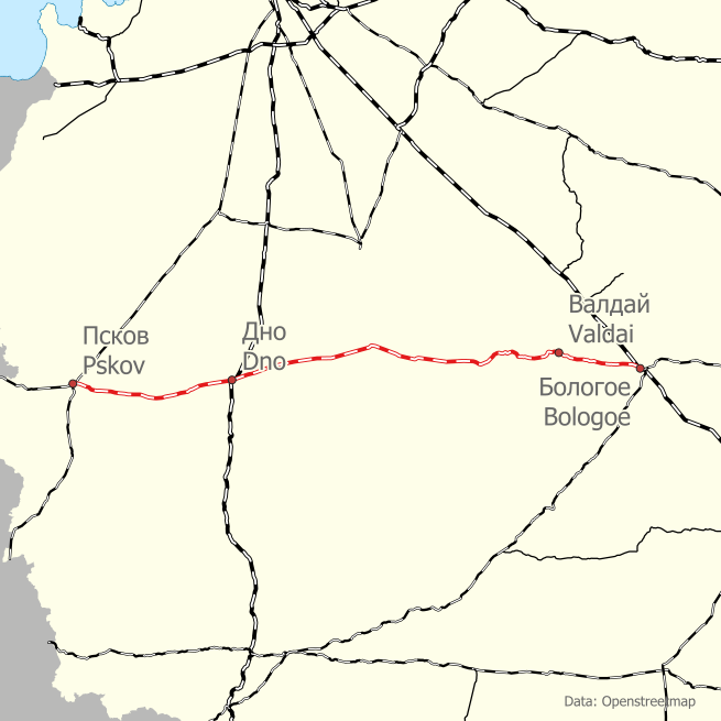
Русский: Карта железзодорожной линии Бологое - Псков |
||||||||||||||||||||||||||
| Date | |||||||||||||||||||||||||||
| Source | Own work https://github.com/trolleway/wikipedia-rail-maps.git | ||||||||||||||||||||||||||
| Creator |
|
||||||||||||||||||||||||||
| Geotemporal data | |||||||||||||||||||||||||||
| Date depicted | after 2010 | ||||||||||||||||||||||||||
| Map location | Новгородская область | ||||||||||||||||||||||||||
| Georeferencing | If inappropriate please set warp_status = skip to hide. | ||||||||||||||||||||||||||
| Bibliographic data | |||||||||||||||||||||||||||
| Language | en, ru | ||||||||||||||||||||||||||
.jpg)
This W3C-unspecified vector image was created with QGIS.
Licensing[edit]
| Description |
This map was created from OpenStreetMap project data, collected by the community. This map may be incomplete, and may contain errors. Don't rely solely on it for navigation. |
|||
| Date | (see file history) | |||
| Source | openstreetmap.org | |||
| Creator |
OpenStreetMap contributors |
|||
| Permission (Reusing this file) |
OpenStreetMap data is available under the Open Database License (details). Map tiles are licensed under the Creative Commons Attribution-ShareAlike 2.0 license (CC-BY-SA 2.0).
This file is licensed under the Creative Commons Attribution-Share Alike 2.0 Generic license.
|
|||
| Georeferencing | If inappropriate please set warp_status = skip to hide. |
File history
Click on a date/time to view the file as it appeared at that time.
| Date/Time | Thumbnail | Dimensions | User | Comment | |
|---|---|---|---|---|---|
| current | 20:48, 20 March 2024 | | 655 × 655 (1,004 KB) | Svetlov Artem (talk | contribs) | =={{int:filedesc}}== {{Map | description = {{ru|1=Карта железзодорожной линии Бологое - Псков}} | date = 2024-03-20 | map_date = {{other date|after|2010}} | source = {{own}} https://github.com/trolleway/wikipedia-rail-maps.git | author = {{Creator:Artem Svetlov}} | permission = | other versions = | wikidata location = | language = en, ru | location = Новгородская область }} {{ Created with QGIS}} =={{int:license-header}}== {{Openstreetmap}} [[Category:Photographs by Artem Svetlov/Railway... |
You cannot overwrite this file.
File usage on Commons
The following 2 pages use this file:
File usage on other wikis
The following other wikis use this file:
- Usage on ru.wikipedia.org
- Usage on www.wikidata.org