File:Map Burgundian Netherlands 1477-fr.svg
From Wikimedia Commons, the free media repository
Jump to navigation
Jump to search

Size of this PNG preview of this SVG file: 523 × 600 pixels. Other resolutions: 209 × 240 pixels | 418 × 480 pixels | 669 × 768 pixels | 893 × 1,024 pixels | 1,785 × 2,048 pixels | 748 × 858 pixels.
Original file (SVG file, nominally 748 × 858 pixels, file size: 126 KB)
File information
Structured data
Captions
Captions
Add a one-line explanation of what this file represents
Summary[edit]
| DescriptionMap Burgundian Netherlands 1477-fr.svg |
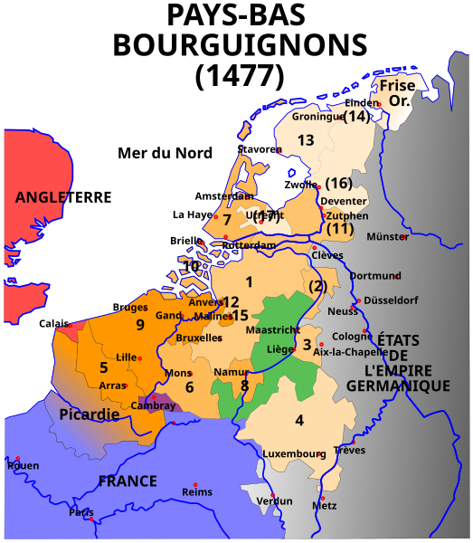
Français : Carte des Pays-Bas bourguignons (1477) |
| Source | Original svg: [1] |
| Author | Denis Jacquerye |
| Other versions |
[edit]
|
Légende[edit]
- En orange, les acquisitions des Ducs de Bourgogne et de Charles Quint.
- 1384 : Artois (5), Flandre (9), Malines (15)
- 1427 : Namur (8)
- 1428 : Hainaut (6), Zélande (10), Hollande (7)
- 1430 : Brabant (1), Limbourg (3)
- 1443 : Luxembourg (4)
- Sous Charles Quint
- Utrecht (17), Frise occidentale et orientale (13), Gueldre (2)
- provinces perdues et reprises: Groningue (14), Overijssel (16), Zutphen (11)
- la Picardie est perdue à la France en 1477.
- En vert, La principauté de Liège indépendante
- En rouge, l'Angleterre
- En bleu, la France
- En noir, d'autres États du Saint Empire romain germanique
|
Les 17 Provinces[edit]
|
Licensing[edit]
This file is licensed under the Creative Commons Attribution-Share Alike 2.5 Generic license.
- You are free:
- to share – to copy, distribute and transmit the work
- to remix – to adapt the work
- Under the following conditions:
- attribution – You must give appropriate credit, provide a link to the license, and indicate if changes were made. You may do so in any reasonable manner, but not in any way that suggests the licensor endorses you or your use.
- share alike – If you remix, transform, or build upon the material, you must distribute your contributions under the same or compatible license as the original.
File history
Click on a date/time to view the file as it appeared at that time.
| Date/Time | Thumbnail | Dimensions | User | Comment | |
|---|---|---|---|---|---|
| current | 21:32, 29 July 2010 |  | 748 × 858 (126 KB) | Chatsam (talk | contribs) | cadre |
| 07:08, 24 September 2005 |  | 744 × 1,052 (125 KB) | Moyogo (talk | contribs) | Carte des Pays-bas bourguignons (1477) Author: Denis Jacquerye Original svg: [http://home.sus.mcgill.ca/~moyogo/maps/1477%20Pays-bas%20bourguignons.svg] ---- === Légende === # En orange, les acquisitions des Ducs de Bourgogne et |
You cannot overwrite this file.
File usage on Commons
The following 7 pages use this file:
- File:1477 Pays-bas bourguignons.svg (file redirect)
- File:Carte Pays-bas espagnol.svg
- File:Map Burgundian Netherlands 1477-af.svg
- File:Map Burgundian Netherlands 1477-en.png
- File:Map Burgundian Netherlands 1477-es.svg
- File:Map Burgundian Netherlands 1477-fr.svg
- Template:Other versions/Map Burgundian Netherlands 1477
File usage on other wikis
The following other wikis use this file:
- Usage on be.wikipedia.org
- Usage on bg.wikipedia.org
- Usage on de.wikipedia.org
- Usage on eo.wikipedia.org
- Usage on fr.wikipedia.org
- Usage on ja.wikipedia.org
- Usage on ro.wikipedia.org
- Usage on ru.wikipedia.org
- Usage on wa.wikipedia.org


