File:Map Crusader states 1135-pt.svg
Jump to navigation
Jump to search

Size of this PNG preview of this SVG file: 441 × 599 pixels. Other resolutions: 177 × 240 pixels | 353 × 480 pixels | 565 × 768 pixels | 754 × 1,024 pixels | 1,508 × 2,048 pixels | 974 × 1,323 pixels.
Original file (SVG file, nominally 974 × 1,323 pixels, file size: 119 KB)
Captions
Captions
Add a one-line explanation of what this file represents
Summary[edit]
| Description |
[]
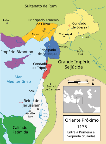
Čeština: Politická mapa Blízkého východu v roce 1135. Deutsch: Die Levante, 1135, zwischen den Ersten und Zweiten Kreuzzügen. Kreuzzugsstaaten sind mit einem roten Kreuz gekennzeichnet Eesti: Lähis-Ida (1135) Español: Oriente Próximo en 1135, entre la primera y segunda cruzadas. Esperanto: Politika mapo de Levantenio dum 1135, inter la krucmilitaroj unuaj kaj duaj. Français : Carte politique du Proche-Orient en 1135, entre la Première et la Seconde Croisades. les États latins d'Orient sont marqués d'une croix rouge. Italiano: Carta politica del Vicino Oriente nel 1135. Magyar: A Közel-Kelet térképe 1135-ben. Polski: Mapa polityczna Bliskiego Wschodu w roku 1135, w okresie II krucjaty. Ελληνικά: Πολιτικός χάρτης της Μέσης Ανατολής το 1135, ανάμεσα στην πρώτη και τη δεύτερη Σταυροφορία Македонски: Политичка карта на Блискиот Исток во 1135 г. Крстоносните држави се означени со црвени крстови. Русский: Карта Ближнего Востока в 1135 г. Српски / srpski: Politička karta Bliskog Istoka 1135. godine, između Prvog i Drugog krstaškog pohoda. Krstaške države su označene crvenim krstom. ქართული: ახლო აღმოსავლეთი 1135 წელს ไทย: แผนที่ตะวันออกกลาง (คศ. 1135) ระหว่างครูเสดครั้งที่ 1 และครั่งที่ 2 中文: 一副关于1135年近东地区局势的地图,标注红色十字的为十字军国家 العربية : الدويلات الصليبية والدول الإسلامية المجاورة لها في الفترة بين الحملتين الصليبيتين الأولى والثانية. فارسی : نسخه فارسی |
||
| Date | |||
| Source |
This file was derived from: Near East 1135.svg:  |
||
| Author | MapMaster (talk · contribs) | ||
| Other versions |
[]
See also[edit] |


-ka.png)


| This is a retouched picture, which means that it has been digitally altered from its original version. Modifications: Portuguese version. The original can be viewed here: Near East 1135.svg:
|
Licensing[edit]
This file is licensed under the Creative Commons Attribution 3.0 Unported license.
- You are free:
- to share – to copy, distribute and transmit the work
- to remix – to adapt the work
- Under the following conditions:
- attribution – You must give appropriate credit, provide a link to the license, and indicate if changes were made. You may do so in any reasonable manner, but not in any way that suggests the licensor endorses you or your use.
File history
Click on a date/time to view the file as it appeared at that time.
| Date/Time | Thumbnail | Dimensions | User | Comment | |
|---|---|---|---|---|---|
| current | 00:25, 4 May 2013 | | 974 × 1,323 (119 KB) | Renato de Carvalho Ferreira (talk | contribs) | Últimas correções! |
| 00:23, 4 May 2013 |  | 974 × 1,323 (118 KB) | Renato de Carvalho Ferreira (talk | contribs) | Correções gerais! | |
| 02:32, 26 March 2013 |  | 974 × 1,323 (118 KB) | Renato de Carvalho Ferreira (talk | contribs) | Tradução do nome "Ascalon" | |
| 05:37, 5 March 2013 |  | 974 × 1,323 (117 KB) | Renato de Carvalho Ferreira (talk | contribs) | Alterei um pouco a disposição de alguns textos para não distorcer tanto em tamanhos menores. | |
| 05:33, 5 March 2013 |  | 974 × 1,323 (119 KB) | Renato de Carvalho Ferreira (talk | contribs) | User created page with UploadWizard |
You cannot overwrite this file.
File usage on Commons
The following 29 pages use this file:
- File:Crusader States (1135)-ka.png
- File:Lähis-Ida 1135.png
- File:Map Crusader states 1135-ar.png
- File:Map Crusader states 1135-cs.svg
- File:Map Crusader states 1135-de.svg
- File:Map Crusader states 1135-de2.svg
- File:Map Crusader states 1135-el.svg
- File:Map Crusader states 1135-en.svg
- File:Map Crusader states 1135-eo.svg
- File:Map Crusader states 1135-es.svg
- File:Map Crusader states 1135-es2.svg
- File:Map Crusader states 1135-fr.svg
- File:Map Crusader states 1135-fr2.svg
- File:Map Crusader states 1135-hu.svg
- File:Map Crusader states 1135-hy.svg
- File:Map Crusader states 1135-it.png
- File:Map Crusader states 1135-jp.png
- File:Map Crusader states 1135-mk.svg
- File:Map Crusader states 1135-nl.svg
- File:Map Crusader states 1135-pl.png
- File:Map Crusader states 1135-pl.svg
- File:Map Crusader states 1135-pt.svg
- File:Map Crusader states 1135-ru.svg
- File:Map Crusader states 1135-zh.svg
- File:Map Crusads states 1135-fa.png
- File:Near East 1135-pt.svg (file redirect)
- File:The Crusader States in 1135-ar.svg
- File:The Crusader States in 1135.svg
- Template:Other versions/Map Crusader states 1135
File usage on other wikis
The following other wikis use this file:
- Usage on es.wikipedia.org
- Usage on pt.wikipedia.org
- Francos
- Império Bizantino
- Primeira Cruzada
- Godofredo de Bulhão
- Segunda Cruzada
- Luís VII de França
- Reino de Jerusalém
- Condado de Trípoli
- Fortaleza dos Cavaleiros
- Estados cruzados
- Principado de Antioquia
- Balduíno I de Jerusalém
- Balduíno II de Jerusalém
- Principado da Galileia
- Boemundo II de Antioquia
- Pôncio de Trípoli
- Zengui
- Melisenda de Jerusalém
- Fulque de Jerusalém
- Joscelino I de Edessa
- Joscelino II de Edessa
- Balduíno III de Jerusalém
- Noradine
- Alice de Antioquia
- Raimundo II de Trípoli
- Cruzada de 1101
- Batalha de Ascalão
- Teodoro de Edessa
- Ricardo de Salerno
- Manuel I Comneno
- Leão I da Arménia
- Batalha do Campo de Sangue
- Batalha de Azaz
- Condado de Jafa e Ascalão
- Guerras bizantino-normandas
- Portal:Cruzadas/Artigo selecionado/3
- Usuário:Renato de Carvalho Ferreira/mapas
- Búridas
- Portal:Cruzadas/Artigo selecionado
- Usage on uk.wikipedia.org
Metadata
Categories:
- Crusader states
- Maps of Cilicia
- Maps of the County of Edessa
- Maps of the County of Tripoli
- Maps of the crusades
- Maps of the history of Cyprus
- Maps of the history of the Levant
- Maps of the history of the Middle East
- Maps of the Kingdom of Jerusalem
- Maps of the Principality of Antioch
- Maps showing 12th-century history
- Portuguese-language SVG maps showing history