File:Map Greece expansion 1832-1947-he.svg
Jump to navigation
Jump to search

Size of this PNG preview of this SVG file: 706 × 599 pixels. Other resolutions: 283 × 240 pixels | 566 × 480 pixels | 905 × 768 pixels | 1,207 × 1,024 pixels | 2,413 × 2,048 pixels | 734 × 623 pixels.
Original file (SVG file, nominally 734 × 623 pixels, file size: 132 KB)
Captions
Captions
Add a one-line explanation of what this file represents
| Description |
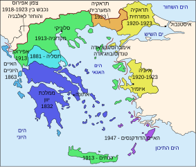
Čeština: Mapa zobrazuje územní expanzi Řeckého království (1832–1947). Dansk: Kort over Grækenlands territoriale udvidelser, 1832-1947. Deutsch: Territoriale Expansion Griechenlands 1832-1947. English: The territorial expansion of Greece, 1832-1947. Español: Mapa de la expansión territorial griega (1832-1947) Euskara: Greziaren lurralde hedapena 1832-1947 bitartean Français : L'expansion territoriale de la Grèce. 1832-1947. Hrvatski: Teritorijalno proširenje Grčke u razdoblju od 1832. do 1947. Italiano: L'espansione territoriale della Grecia dal 1832 al 1947 Magyar: Görögország területi növekedése (1832-1947) Occitan : Evolucions territòrialas de Grècia. Ελληνικά: Η εδαφική επέκταση της Ελλάδας 1832-1947. Македонски: Територијално проширување на Грција Українська: Територіальна експансія Греції (1832-1947). 日本語: ギリシャ王国の版図拡大 (1832-1947年) 中文: 希腊的领土变迁,1832年-1947年间。 العربية : خريطة تُصوِّر الأراضي التي استولت عليها اليونان مُنذُ سنة 1832م حين استقلالها عن الدولة العُثمانيَّة، وُصولًا إلى سنة 1947م |
||||||||
| Source | own after File:Map Greece expansion 1832-1947-en.svg | ||||||||
| Author | User:Ori~ | ||||||||
| Permission (Reusing this file) |
|
||||||||
| Other versions |
[]
|


.PNG)


.png)


File history
Click on a date/time to view the file as it appeared at that time.
| Date/Time | Thumbnail | Dimensions | User | Comment | |
|---|---|---|---|---|---|
| current | 09:44, 12 August 2009 | | 734 × 623 (132 KB) | GilCahana (talk | contribs) | . |
| 14:34, 11 August 2009 |  | 734 × 962 (141 KB) | Ori~ (talk | contribs) | rf | |
| 14:33, 11 August 2009 |  | 734 × 962 (141 KB) | Ori~ (talk | contribs) | ed | |
| 14:28, 11 August 2009 |  | 734 × 962 (148 KB) | Ori~ (talk | contribs) | s | |
| 14:24, 11 August 2009 |  | 734 × 962 (144 KB) | Ori~ (talk | contribs) | e | |
| 14:18, 11 August 2009 |  | 734 × 962 (140 KB) | Ori~ (talk | contribs) | ed | |
| 14:15, 11 August 2009 |  | 734 × 962 (145 KB) | Ori~ (talk | contribs) | ed | |
| 14:07, 11 August 2009 |  | 734 × 962 (135 KB) | Ori~ (talk | contribs) | {{Information |Description=File:Map Greece expansion 1832-1947 HE |Source=own after File:Map Greece expansion 1832-1947-en.svg |Author=User:Ori~ |Permission={{GFDL|migration=relicense}} |other_versions= }} Category:Maps of Greece [[Category: |
You cannot overwrite this file.
File usage on Commons
The following 31 pages use this file:
- User:GilCahana
- File:ExpansionofModernGreece.png
- File:Greek history from 1832-ar.png
- File:Greek history from 1832.GIF
- File:Greekhistory-zh-classical.png
- File:Greekhistory el.gif
- File:Grècia - Evolucions territòrialas.png
- File:La expansión territorial de Grecia (1832-1947).PNG
- File:Map Greece Megali Idea (hy).png
- File:Map Greece expansion 1832-1947-HE.svg
- File:Map Greece expansion 1832-1947-ar.svg
- File:Map Greece expansion 1832-1947-cs-2.svg
- File:Map Greece expansion 1832-1947-da.svg
- File:Map Greece expansion 1832-1947-el.svg
- File:Map Greece expansion 1832-1947-en.svg
- File:Map Greece expansion 1832-1947-es.svg
- File:Map Greece expansion 1832-1947-eu.png
- File:Map Greece expansion 1832-1947-fr.svg
- File:Map Greece expansion 1832-1947-he.svg
- File:Map Greece expansion 1832-1947-hr.svg
- File:Map Greece expansion 1832-1947-hu.svg
- File:Map Greece expansion 1832-1947-it.svg
- File:Map Greece expansion 1832-1947-mk.svg
- File:Map Greece expansion 1832-1947-nl.svg
- File:Map Greece expansion 1832-1947-sr.svg
- File:Map Greece expansion 1832-1947-zhcn.svg
- File:Map Greece expansion 1832-1947 ja.svg
- File:Territorial Expansion of Greece from 1832–1947.gif
- File:Επέκταση Ελλάδας 1832-1947.svg
- File:Територіальна експансія Греції в 1832-1947рр.png
- Template:Other versions/Map Greece expansion 1832-1947
File usage on other wikis
The following other wikis use this file:
- Usage on he.wikipedia.org