File:Map of BRICS members and other countries which are either joining, had applied to join, or had expressed an interest in joining BRICS-WITH Antarctica.svg

Original file (SVG file, nominally 2,754 × 1,398 pixels, file size: 1.13 MB)
Captions
Captions
Summary[edit]
| Description |
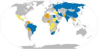
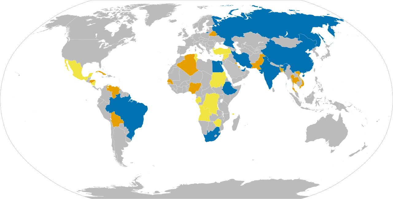
English: Map of countries relationship to BRICS. MAP KEY: Blue: Members states, Orange: Applicants, Yellow: expressed an interest in joining, Bluish-Green: rejected invitation offer to join |
| Date | |
| Source | Own work |
| Author | MathSquare |
| Other versions |
|


Author's Note to any future editor[edit]
Firstly, please do not change the color scheme or palette of this image. Its work! Its works for all of the people who has a form of a color deficiency as I made sure to send it though an application to check. It's very clear regardless on how the person sees. The only exception is when the person can not see any colors at all (monochromacy). However, that is not really an concern because it's super rare and they are practically blind due to everything is almost always too bright for them. So even if we try to make it work for them they couldn't really see it anyways.
Secondly, keep in mind it's very hard to makes something that works for all. It's impossible as you would have to make different versions as if you improve it for one group, you would disimprove it for another. For the people which it doesn't work for, we are just better off making sure there is a list of countries which they can use a text to speech program instead on. This is practically the best we can do and it would probably be better for them since the person wouldn't have to struggle to see the map if it's even possible for them.
For example, if we adopt an all grayscale approach then probably most would struggle to understand the map due to the lack of the ability to tell the difference in the slight difference in the shade of the color. Keep in mind that people may not have a good screen which can reproduce the colors correctly or have good enough vision to tell. So this would be clearly in downgrade in quality.
Thirdly, If we do really want to change an existing color then please use one in our accessibility guidelines AND before changing let's discuss it to make sure it's the right approach. It's also not only the assability. It's also where this image is used and all of the translations and articles which we would need to edit. It's used on now 10 different language wikipedias. For example, if we changed the colors completely yet still kept the previous key on all of them then I can not imagine on how much confusion that would create. I personally feel that our color system is intuitive on this picture as well as it's looks good, not only to people who has normal color vision but to basically all but that is only my opinion.
Lastly, feel free to change anything including on what I said here to make it more clear and to improve this page/map assuming if it doesn't break anything and if we would want it as a group as this is an collaborative project like everything on Wikipedia and should be treated as that. Also, do not forget this image should be in alignment with this image as well as it's an extension upon it: https://commons.wikimedia.org/wiki/File:BRICS.svg AND since this map is following the guidance of the guidelines we have for accessibility, DO NOT BREAK IT. The guidelines are located here: https://en.wikipedia.org/wiki/Help:Using_colours and here: https://commons.wikimedia.org/wiki/Commons:Creating_accessible_illustrations .
-MathSquare
Thanks for contributing[edit]
Contributed directly to the image: Peter Njeim, Allice Hunter, Rumahkedua AlexWelens, and YanchikYT
Protecting the image: M.Bitton
Give information to make the map more accurate or reflective of current conditions: EvoSwatch, Onwa, and Khonziwe
Different coloring ideas to try to make the map easier to understand: Peter Njeim, Aammii, and Camdoodlebop
Information and metadata of this article: Sleepych, and Pargis
Licensing[edit]
| This file is made available under the Creative Commons CC0 1.0 Universal Public Domain Dedication. | |
| The person who associated a work with this deed has dedicated the work to the public domain by waiving all of their rights to the work worldwide under copyright law, including all related and neighboring rights, to the extent allowed by law. You can copy, modify, distribute and perform the work, even for commercial purposes, all without asking permission.
|
File history
Click on a date/time to view the file as it appeared at that time.
| Date/Time | Thumbnail | Dimensions | User | Comment | |
|---|---|---|---|---|---|
| current | 02:25, 3 February 2024 | | 2,754 × 1,398 (1.13 MB) | Cergun62 (talk | contribs) | Putting Saudi Arabia on hold as it hasn't officially joined BRICS yet according to Reuters: https://www.reuters.com/world/saudi-arabia-has-not-yet-joined-brics-saudi-official-source-2024-02-01/ |
| 17:32, 1 February 2024 |  | 2,754 × 1,398 (1.13 MB) | Cergun62 (talk | contribs) | Saudi Arabia has officially joined. | |
| 12:25, 17 January 2024 |  | 2,754 × 1,398 (1.13 MB) | Lades2222 (talk | contribs) | Saudi Arabia on hold. | |
| 16:39, 16 January 2024 |  | 2,754 × 1,398 (1.13 MB) | InterDimensional14 (talk | contribs) | Added Pakistan as applicant country | |
| 13:36, 30 December 2023 |  | 2,754 × 1,398 (1.13 MB) | Lades2222 (talk | contribs) | / | |
| 12:49, 30 December 2023 |  | 2,754 × 1,398 (1.13 MB) | Lades2222 (talk | contribs) | Is it really necessary to ‘reject the offer’? It's the same as not signing up. The important issue is the positive situation for joining. | |
| 10:35, 30 December 2023 |  | 2,754 × 1,398 (1.13 MB) | Lades2222 (talk | contribs) | Update. | |
| 22:54, 20 September 2023 |  | 2,754 × 1,398 (1.13 MB) | Mathsquare (talk | contribs) | Fix the Russia. | |
| 20:51, 19 September 2023 |  | 2,754 × 1,398 (1.12 MB) | Mathsquare (talk | contribs) | Better code, reworked | |
| 16:33, 19 September 2023 |  | 2,756 × 1,399 (871 KB) | Mathsquare (talk | contribs) | Forgot to add Indonesia |
You cannot overwrite this file.
File usage on Commons
The following 3 pages use this file:
File usage on other wikis
The following other wikis use this file:
- Usage on en.wikipedia.org
- Usage on ne.wikipedia.org
- Usage on th.wikipedia.org
- Usage on vi.wikipedia.org