File:Map of Greater Nepal (with part of ceded territory).jpg

Original file (8,841 × 3,225 pixels, file size: 3.91 MB, MIME type: image/jpeg)
Captions
Captions
Summary
[edit].jpg&action=edit§ion=1)
| Description |
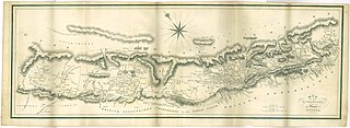
English: Map of the dominions of the House of Gorkha from Francis Hamilton M. D. named "An Account of the Kingdom of Nepal and the Territories annexed to this Dominion by the House of Gorkha", 1819. |
| Date | |
| Source | https://dl.wdl.org/2372_1_387.png, https://pahar.in/wpfb-file/1819-An-Account-of-the-Kingdom-of-Nepal-by-Hamilton-s-pdf |
| Author | W. & D. Edinburgh |
Licensing
[edit].jpg&action=edit§ion=2)
|
This is a faithful photographic reproduction of a two-dimensional, public domain work of art. The work of art itself is in the public domain for the following reason:
The official position taken by the Wikimedia Foundation is that "faithful reproductions of two-dimensional public domain works of art are public domain".
This photographic reproduction is therefore also considered to be in the public domain in the United States. In other jurisdictions, re-use of this content may be restricted; see Reuse of PD-Art photographs for details. | ||||
File history
Click on a date/time to view the file as it appeared at that time.
| Date/Time | Thumbnail | Dimensions | User | Comment | |
|---|---|---|---|---|---|
| current | 06:52, 13 September 2020 | 8,841 × 3,225 (3.91 MB) | Raju Babu (talk | contribs) | Uploaded a work by W. & D. Edinburgh from https://dl.wdl.org/2372_1_387.png with UploadWizard |
You cannot overwrite this file.
File usage on Commons
The following 2 pages use this file:
File usage on other wikis
The following other wikis use this file:
- Usage on ar.wikipedia.org
- Usage on bn.wikipedia.org
- Usage on ca.wikipedia.org
- Usage on en.wikipedia.org
- Usage on es.wikipedia.org
- Usage on eu.wikipedia.org
- Usage on fr.wikipedia.org
- Usage on uk.wikipedia.org
- Usage on www.wikidata.org
.jpg&oldid=881911583)