File:Map of High Speed Railroad in Czechia and neighbourhood.png
Jump to navigation
Jump to search
Size of this preview: 800 × 545 pixels. Other resolutions: 320 × 218 pixels | 640 × 436 pixels | 1,024 × 697 pixels | 1,280 × 871 pixels | 1,880 × 1,280 pixels.
Original file (1,880 × 1,280 pixels, file size: 418 KB, MIME type: image/png)
Captions
Captions
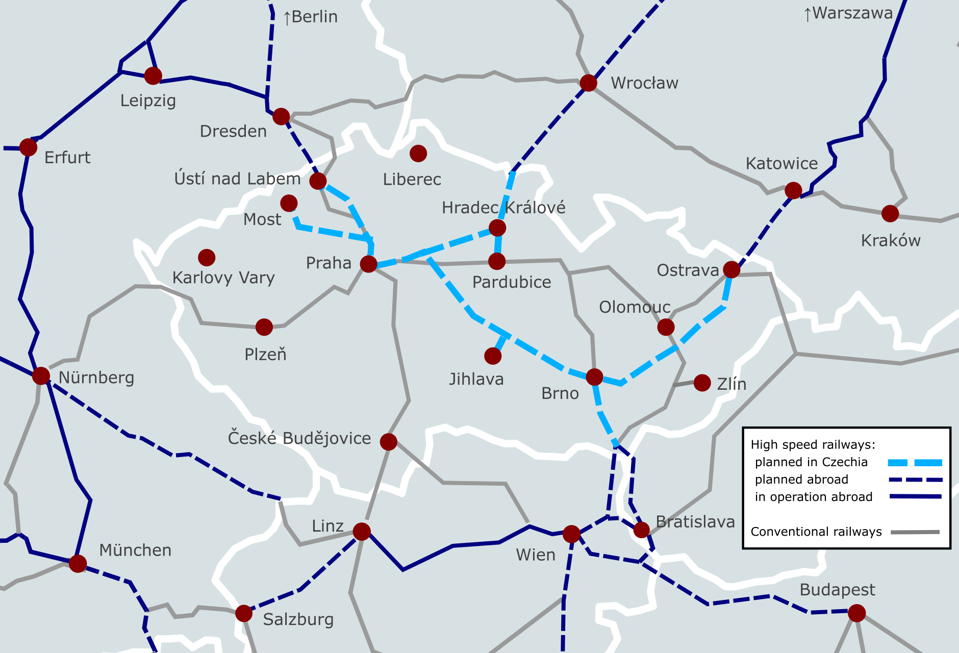
Map of planned and operational high-speed railroad in Czechia and its neighbourhood.
Summary[edit]
| Description |
English: Map showing planned and operational high-speed railroads in Czechia and the neighbouring countries of Germany, Poland, Slovakia and Austria. |
| Date | |
| Source | Own work |
| Author | NeuP |
Licensing[edit]
I, the copyright holder of this work, hereby publish it under the following license:
This file is licensed under the Creative Commons Attribution-Share Alike 4.0 International license.
- You are free:
- to share – to copy, distribute and transmit the work
- to remix – to adapt the work
- Under the following conditions:
- attribution – You must give appropriate credit, provide a link to the license, and indicate if changes were made. You may do so in any reasonable manner, but not in any way that suggests the licensor endorses you or your use.
- share alike – If you remix, transform, or build upon the material, you must distribute your contributions under the same or compatible license as the original.
File history
Click on a date/time to view the file as it appeared at that time.
| Date/Time | Thumbnail | Dimensions | User | Comment | |
|---|---|---|---|---|---|
| current | 10:22, 1 November 2023 | | 1,880 × 1,280 (418 KB) | NeuP (talk | contribs) | Uploaded own work with UploadWizard |
You cannot overwrite this file.
File usage on Commons
The following 2 pages use this file:
File usage on other wikis
The following other wikis use this file:
- Usage on cs.wikipedia.org
- Usage on de.wikipedia.org
- Usage on en.wikipedia.org
- Usage on fr.wikipedia.org