File:Map of Japan in Nishi-Oyama Station.jpg
Jump to navigation
Jump to search

Size of this preview: 799 × 599 pixels. Other resolutions: 320 × 240 pixels | 640 × 480 pixels | 1,024 × 768 pixels | 1,280 × 960 pixels | 2,560 × 1,920 pixels | 4,003 × 3,003 pixels.
Original file (4,003 × 3,003 pixels, file size: 2.37 MB, MIME type: image/jpeg)
Captions
Captions
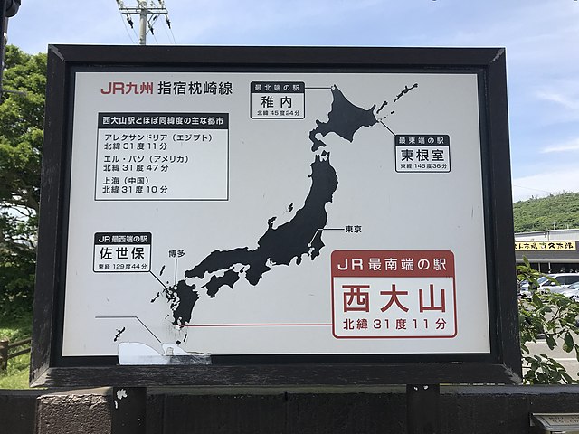
Map at Nishi-Ōyama Station showing the furthest JR stations of the home islands.
Summary[edit]
| Description |
日本語: 西大山駅にあるJR東西南北端の駅を示す地図 English: Map at Nishi-Ōyama indicating it as the southernmost station of JR Group. The map also shows Okudōkai, Wakkanai and Higashi-Nemuro as the westernmost, northernmost and easternmost stations of JR Group, respectively. |
| Date | |
| Source | Own work |
| Author | そらみみ |
| Camera location | | View this and other nearby images on: OpenStreetMap |
|---|
Licensing[edit]
I, the copyright holder of this work, hereby publish it under the following license:
This file is licensed under the Creative Commons Attribution-Share Alike 4.0 International license.
- You are free:
- to share – to copy, distribute and transmit the work
- to remix – to adapt the work
- Under the following conditions:
- attribution – You must give appropriate credit, provide a link to the license, and indicate if changes were made. You may do so in any reasonable manner, but not in any way that suggests the licensor endorses you or your use.
- share alike – If you remix, transform, or build upon the material, you must distribute your contributions under the same or compatible license as the original.
File history
Click on a date/time to view the file as it appeared at that time.
| Date/Time | Thumbnail | Dimensions | User | Comment | |
|---|---|---|---|---|---|
| current | 04:18, 6 July 2018 | | 4,003 × 3,003 (2.37 MB) | そらみみ (talk | contribs) | User created page with UploadWizard |
You cannot overwrite this file.
File usage on Commons
The following page uses this file:
File usage on other wikis
The following other wikis use this file:
- Usage on en.wikipedia.org
- Usage on ja.wikipedia.org
- Usage on zh.wikipedia.org