File:Map of Knickebein transmitters.svg
Jump to navigation
Jump to search

Size of this PNG preview of this SVG file: 527 × 599 pixels. Other resolutions: 211 × 240 pixels | 422 × 480 pixels | 676 × 768 pixels | 901 × 1,024 pixels | 1,802 × 2,048 pixels | 658 × 748 pixels.
Original file (SVG file, nominally 658 × 748 pixels, file size: 112 KB)
Captions
Captions
Add a one-line explanation of what this file represents
Summary
[edit]
| Description |
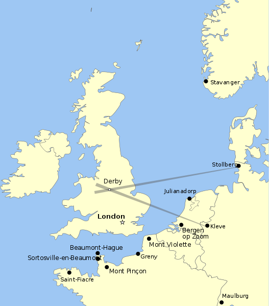
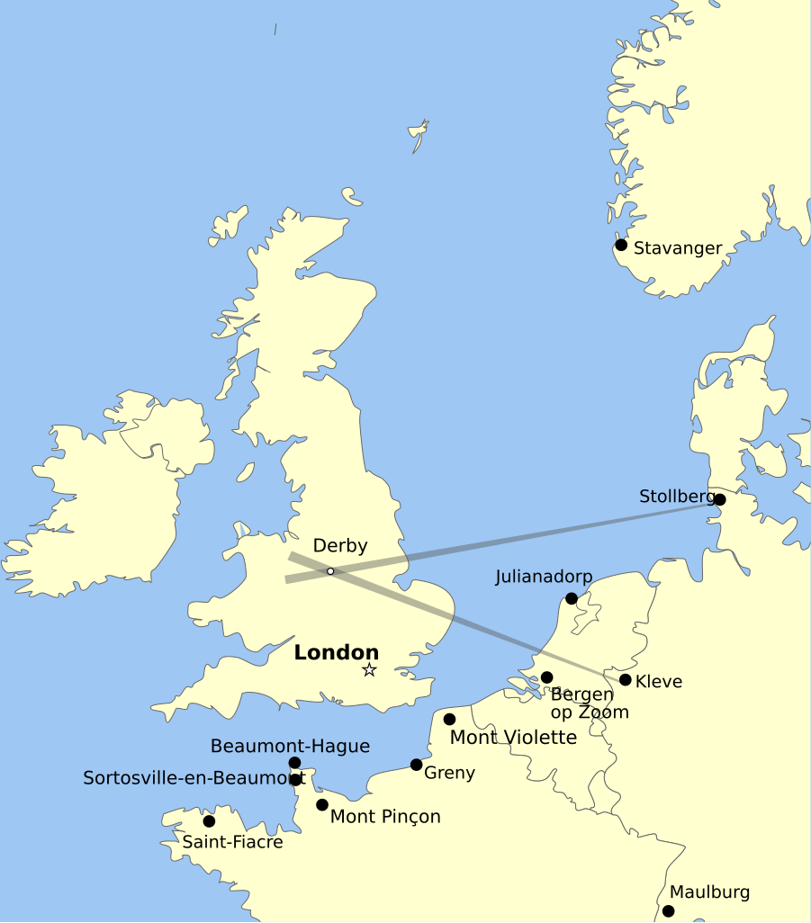
English: Map showing the positions of Knickebein transmitters during the battle of Britain. |
| Date | |
| Source | Own work |
| Author | Dahnielson |
Licensing
[edit]
I, the copyright holder of this work, hereby publish it under the following licenses:
This file is licensed under the Creative Commons Attribution-Share Alike 3.0 Unported license.
- You are free:
- to share – to copy, distribute and transmit the work
- to remix – to adapt the work
- Under the following conditions:
- attribution – You must give appropriate credit, provide a link to the license, and indicate if changes were made. You may do so in any reasonable manner, but not in any way that suggests the licensor endorses you or your use.
- share alike – If you remix, transform, or build upon the material, you must distribute your contributions under the same or compatible license as the original.

|
Permission is granted to copy, distribute and/or modify this document under the terms of the GNU Free Documentation License, Version 1.2 or any later version published by the Free Software Foundation; with no Invariant Sections, no Front-Cover Texts, and no Back-Cover Texts. A copy of the license is included in the section entitled GNU Free Documentation License. |
You may select the license of your choice.
File history
Click on a date/time to view the file as it appeared at that time.
| Date/Time | Thumbnail | Dimensions | User | Comment | |
|---|---|---|---|---|---|
| current | 06:47, 26 August 2011 | | 658 × 748 (112 KB) | Chriusha (talk | contribs) | Position of K 11 corrected, see Disk |
| 15:38, 13 May 2011 |  | 658 × 748 (112 KB) | Hohum (talk | contribs) | More readable text. | |
| 22:18, 21 April 2010 |  | 658 × 748 (113 KB) | Dahnielson (talk | contribs) | Made the beams nicer, changed the Stollberg label and hopefully fixed the font rendering. Category:Radio navigation Category:Battle of Britain | |
| 22:14, 20 April 2010 |  | 658 × 748 (114 KB) | Dahnielson (talk | contribs) | Added Julianadorp and Bergen op Zoom to map | |
| 21:50, 20 April 2010 |  | 658 × 748 (111 KB) | Dahnielson (talk | contribs) | Added transmitter locations and the Kleve/Stollberg beams targeting Derby as an example. | |
| 19:19, 20 April 2010 |  | 658 × 748 (103 KB) | Dahnielson (talk | contribs) | Reverted to version as of 18:47, 20 April 2010 | |
| 19:18, 20 April 2010 |  | 658 × 748 (103 KB) | Dahnielson (talk | contribs) | Try to fix the font issue. | |
| 18:47, 20 April 2010 |  | 658 × 748 (103 KB) | Dahnielson (talk | contribs) | {{Information |Description={{en|1=Map showing the positions of Knickebein transmitters during the battle of Britain.}} |Source={{own}} |Author=Dahnielson |Date=2010-04-20 |Permission= |other_versions= }} |
You cannot overwrite this file.
File usage on Commons
There are no pages that use this file.
File usage on other wikis
The following other wikis use this file:
- Usage on ar.wikipedia.org
- Usage on de.wikipedia.org
- Usage on en.wikipedia.org
- Usage on es.wikipedia.org
- Usage on fr.wikipedia.org
- Usage on he.wikipedia.org
- Usage on sk.wikipedia.org