File:Map of Lews Castle.png
Jump to navigation
Jump to search

Size of this preview: 663 × 599 pixels. Other resolutions: 266 × 240 pixels | 531 × 480 pixels | 850 × 768 pixels | 1,133 × 1,024 pixels | 1,401 × 1,266 pixels.
Original file (1,401 × 1,266 pixels, file size: 572 KB, MIME type: image/png)
Captions
Captions
Add a one-line explanation of what this file represents
| Description |
|
| Date | see file history |
| Source | Own work using: OpenStreetMap data for the background |
| Author | Maximilian Dörrbecker (Chumwa) |
| Permission (Reusing this file) |
All OpenStreetMap data and maps are Creative Commons "CC-BY-SA 2.0" licensed This file is licensed under the Creative Commons Attribution-Share Alike 2.0 Generic license.
|
| This work contains information from OpenStreetMap, which is made available under the Open Database License (ODbL).
The ODbL does not require any particular license for maps produced from ODbL data. Prior to 1 August 2020, map tiles produced by the OpenStreetMap Foundation were licensed under the CC-BY-SA-2.0 license. Maps produced by other people may be subject to other licences. |
File history
Click on a date/time to view the file as it appeared at that time.
| Date/Time | Thumbnail | Dimensions | User | Comment | |
|---|---|---|---|---|---|
| current | 20:30, 3 November 2017 | | 1,401 × 1,266 (572 KB) | Chumwa (talk | contribs) | |
| 09:41, 29 October 2017 |  | 1,401 × 1,266 (569 KB) | Chumwa (talk | contribs) | ||
| 20:12, 27 October 2017 |  | 1,479 × 1,266 (540 KB) | Chumwa (talk | contribs) | ||
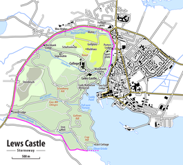
| 19:32, 27 October 2017 |  | 1,479 × 1,266 (540 KB) | Chumwa (talk | contribs) | {{Information |Description= *{{de|Karte von Lews Castle in Stornoway}} *{{en|Map of Lews Castle in Stornoway}} |Author=Maximilian Dörrbecker (Chumwa) |Source={{own using}} OpenStreetMap data for the backgrou... |
You cannot overwrite this file.
File usage on Commons
The following page uses this file:
File usage on other wikis
The following other wikis use this file: