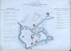
File:Map of Lutsk 1860.jpg
Map_of_Lutsk_1860.jpg (760 × 564 pixels, file size: 97 KB, MIME type: image/jpeg)
Captions
Captions
Summary
[edit]| DescriptionMap of Lutsk 1860.jpg |
English: Map of Lutsk 1860
Русский: Карта Луцка 1860 года. Официальное название: «Планъ части города Луцка съ показаніемъ находящихся въ немъ памятниковъ русской древности» |
| Date | |
| Source |
Русский: Історичні карти Луцька. ФОТО из "Памятники русской старины в западных губерниях. - СПб., 1868-1885. - 8 т." |
| Author |
Русский: Автор: Помпей Николаевич Батюшков, иллюстрации Петра Струкова. |
| Other versions |
|
Licensing
[edit]| Public domainPublic domainfalsefalse |
|
This work is in the public domain in its country of origin and other countries and areas where the copyright term is the author's life plus 100 years or fewer. | |
| This file has been identified as being free of known restrictions under copyright law, including all related and neighboring rights. | |
https://creativecommons.org/publicdomain/mark/1.0/PDMCreative Commons Public Domain Mark 1.0falsefalse
| Public domainPublic domainfalsefalse |
This work is in the public domain in the United States because it was published (or registered with the U.S. Copyright Office) before January 1, 1929.
Public domain works must be out of copyright in both the United States and in the source country of the work in order to be hosted on the Commons. If the work is not a U.S. work, the file must have an additional copyright tag indicating the copyright status in the source country.
Note: This tag should not be used for sound recordings.PD-1923Public domain in the United States//commons.wikimedia.org/wiki/File:Map_of_Lutsk_1860.jpg |
File history
Click on a date/time to view the file as it appeared at that time.
| Date/Time | Thumbnail | Dimensions | User | Comment | |
|---|---|---|---|---|---|
| current | 12:18, 16 November 2016 |  | 760 × 564 (97 KB) | Krassotkin (talk | contribs) | User created page with UploadWizard |
You cannot overwrite this file.
File usage on Commons
The following 2 pages use this file:
Metadata
This file contains additional information such as Exif metadata which may have been added by the digital camera, scanner, or software program used to create or digitize it. If the file has been modified from its original state, some details such as the timestamp may not fully reflect those of the original file. The timestamp is only as accurate as the clock in the camera, and it may be completely wrong.
| JPEG file comment | CREATOR: gd-jpeg v1.0 (using IJG JPEG v80), quality = 100 |
|---|

