File:Map of South Dakota highlighting Armstrong County.svg
Jump to navigation
Jump to search

Size of this PNG preview of this SVG file: 243 × 153 pixels. Other resolutions: 320 × 201 pixels | 640 × 403 pixels | 1,024 × 645 pixels | 1,280 × 806 pixels | 2,560 × 1,612 pixels.
Original file (SVG file, nominally 243 × 153 pixels, file size: 16 KB)
Captions
Captions
Add a one-line explanation of what this file represents
Summary
[edit]
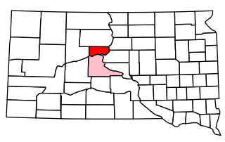
| Description | A map of South Dakota with its 1928 counties, highlighting Armstrong in red and Stanley, to which Armstrong was formally attached, in pinl. | |||
| Source | Adapted from File:South Dakota Presidential Election Results 1928.svg rather than the other "highlighting" images, so edges/etc. might be wacky | |||
| Author | ||||
| Permission (Reusing this file) |
|
File history
Click on a date/time to view the file as it appeared at that time.
| Date/Time | Thumbnail | Dimensions | User | Comment | |
|---|---|---|---|---|---|
| current | 01:08, 11 March 2023 | | 243 × 153 (16 KB) | John M Wolfson (talk | contribs) | {{Information |Description= A map of South Dakota with its 1928 counties, highlighting Armstrong in red and Stanley, to which Armstrong was formally attached, in pinl. |Source= Adapted from File:South Dakota Presidential Election Results 1928.svg rather than the other "highlighting" images, so edges/etc. might be wacky |Date= |Author= |Permission= Public domain since it's a map and/or polygons; if neither of those work I release this into the public domain/CC0. |other_versions= }} |
You cannot overwrite this file.
File usage on Commons
There are no pages that use this file.
File usage on other wikis
The following other wikis use this file:
- Usage on en.wikipedia.org