File:Map of Tibet and Pangong Lake in 1873 from Hindutagh-pass-aksai-chin-center2-1873 (cropped).jpg
Jump to navigation
Jump to search

Size of this preview: 599 × 600 pixels. Other resolutions: 240 × 240 pixels | 480 × 480 pixels | 767 × 768 pixels | 1,130 × 1,131 pixels.
Original file (1,130 × 1,131 pixels, file size: 205 KB, MIME type: image/jpeg)
Captions
Captions
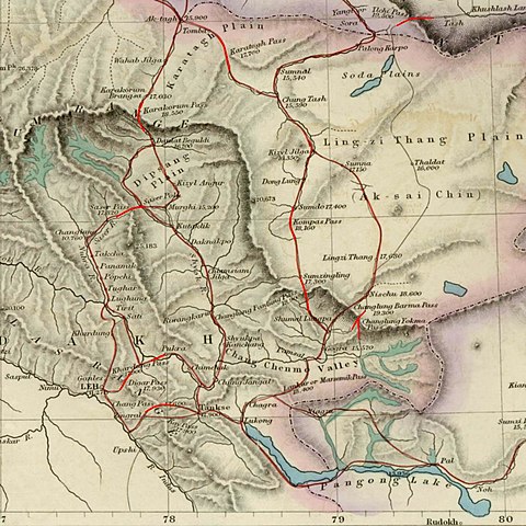
Trade routes of Ladakh with Turkestan and Tibet, 1878
Summary[edit]

|
This file was moved to Wikimedia Commons from en.wikipedia using a bot script. All source information is still present. It requires review. Additionally, there may be errors in any or all of the information fields; information on this file should not be considered reliable and the file should not be used until it has been reviewed and any needed corrections have been made. Once the review has been completed, this template should be removed. For details about this file, see below. Check now! |
| Description |
English: Image of map of the Baltistan, Aksai Chin, Chinese Turkestan in maps of Central Asia. The international border between the British Indian Empire (including the Kashmir region) and Chinese Turkestan is shown two-toned purple and pink. From the article, "On the Geographical Results of the Mission to Kashghar, under Sir T. Douglas Forsyth in 1873-74" by H. Trotter
Journal of the Royal Geographical Society of London, Vol. 48. (1878), pp. 173-234. Downloaded, resized to 33% of original size and annotated by Fowler&fowler«Talk» 23:52, 8 July 2007 (UTC) |
| Date | |
| Source | Article= "On the Geographical Results of the Mission to Kashghar, under Sir T. Douglas Forsyth in 1873-74" by H. Trotter, Journal of the Royal Geographical Society of London, Vol. 48. (1878), pp. 173-234. |
| Author | H. Trotter |
| Other versions |

Licensing[edit]
|
This is a faithful photographic reproduction of a two-dimensional, public domain work of art. The work of art itself is in the public domain for the following reason:
The official position taken by the Wikimedia Foundation is that "faithful reproductions of two-dimensional public domain works of art are public domain".
This photographic reproduction is therefore also considered to be in the public domain in the United States. In other jurisdictions, re-use of this content may be restricted; see Reuse of PD-Art photographs for details. |


.jpg&action=edit§ion=1)
.jpg&action=edit&withJS=MediaWiki:Botcheck.js)
.jpg&action=edit§ion=2)
Original upload log[edit]
.jpg&action=edit§ion=3)
The original description page was here. All following user names refer to en.wikipedia.
- 2007-07-08 23:50 Fowler&fowler 1386×1980× (419033 bytes) Image of map of Central Asia from the article, [http://www.jstor.org/stable/1798763 "On the Geographical Results of the Mission to Kashghar, under Sir T. Douglas Forsyth in 1873-74"] by H. Trotter ''Journ
| Annotations | This image is annotated: View the annotations at Commons |
.jpg)
File history
Click on a date/time to view the file as it appeared at that time.
| Date/Time | Thumbnail | Dimensions | User | Comment | |
|---|---|---|---|---|---|
| current | 00:22, 25 April 2019 | | 1,130 × 1,131 (205 KB) | Tibet Nation (talk | contribs) | File:Hindutagh-pass-aksai-chin-center2-1873.jpg cropped 18 % horizontally, 43 % vertically using CropTool with lossless mode. |
You cannot overwrite this file.
File usage on Commons
The following page uses this file:
File usage on other wikis
The following other wikis use this file:
- Usage on en.wikipedia.org
- Usage on pa.wikipedia.org
- Usage on pnb.wikipedia.org
Metadata
.jpg&oldid=720350942)
Categories:
- Maps of trade routes
- Maps of the history of Ladakh
- Mountain passes of Tibet
- Maps of Aksai Chin
- Topographic maps of Asia
- Old maps that include Leh
- Karakoram
- Shyok River (India)
- Mountain passes of Ladakh
- Chang La
- Kay Pass
- Digar Pass
- Khardung La
- Changlung Yokma Pass
- Changlung Barma Pass
- Changlung Pantung Pass
- Kompas Pass
- Saser Pass
- Karakorum Pass
- Maps of Chang Chenmo Valley
- Marsemik La
- Maps of the history of Kashmir
- Karatagh Pass
- Maps of Galwan Valley