File:Map of USA CA.svg
Jump to navigation
Jump to search

Size of this PNG preview of this SVG file: 286 × 186 pixels. Other resolutions: 320 × 208 pixels | 640 × 416 pixels | 1,024 × 666 pixels | 1,280 × 832 pixels | 2,560 × 1,665 pixels.
Original file (SVG file, nominally 286 × 186 pixels, file size: 167 KB)
Captions
Captions
Add a one-line explanation of what this file represents
Clickable version
Summary
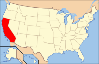
| Description | Map of USA with California highlighted | ||||||||
| Source |
Modified version of United States (Outline Map) 1998 from Perry-Castañeda Library Map Collection: United States Maps |
||||||||
| Author | Huebi | ||||||||
| Permission (Reusing this file) |
This file is licensed under the Creative Commons Attribution 2.0 Generic license.
This file is licensed under the Creative Commons Attribution-Share Alike 1.0 Generic license.
This file is licensed under the Creative Commons Attribution-Share Alike 2.0 Generic license.
|
||||||||
| Other versions | Map of USA with state names.svg | ||||||||
| SVG development | This locator map was created with Inkscape. |

File history
Click on a date/time to view the file as it appeared at that time.
| Date/Time | Thumbnail | Dimensions | User | Comment | |
|---|---|---|---|---|---|
| current | 15:26, 6 November 2020 | | 286 × 186 (167 KB) | HueMan1 (talk | contribs) | Reverted to version as of 12:42, 13 June 2006 (UTC): Inconsistent |
| 15:57, 20 November 2016 |  | 1,181 × 731 (1.86 MB) | Spartan7W (talk | contribs) | Higher quality map | |
| 12:42, 13 June 2006 |  | 286 × 186 (167 KB) | Huebi~commonswiki (talk | contribs) | {{Information| |Description=Map of USA with California highlighted |other_versions=image:Map of USA with state names.svg }} Category:Maps of the United States Category:Maps of California Category:SVG maps {{GFDL-en}}{{cc-by-2.0}}{{cc-by |
You cannot overwrite this file.
File usage on Commons
The following 7 pages use this file:
File usage on other wikis
The following other wikis use this file:
- Usage on af.wikipedia.org
- Usage on als.wikipedia.org
- Usage on ang.wikipedia.org
- Usage on an.wikipedia.org
- Usage on ar.wikipedia.org
- Usage on ay.wikipedia.org
- Usage on azb.wikipedia.org
- Usage on az.wiktionary.org
- Usage on ba.wikipedia.org
- Usage on bcl.wikipedia.org
- Usage on bg.wikipedia.org
- Usage on bo.wikipedia.org
- Usage on bpy.wikipedia.org
- Usage on bxr.wikipedia.org
- Usage on ca.wikipedia.org
- Usage on chy.wikipedia.org
- Usage on co.wikipedia.org
- Usage on cs.wikipedia.org
- Usage on da.wikipedia.org
View more global usage of this file.