File:Map of USA highlighting Corn Belt.png
Jump to navigation
Jump to search
No higher resolution available.
Map_of_USA_highlighting_Corn_Belt.png (280 × 183 pixels, file size: 41 KB, MIME type: image/png)
Captions
Captions
Add a one-line explanation of what this file represents
Summary[edit]
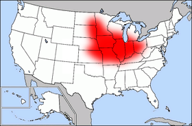
| Description | Public domain map courtesy of The General Libraries, The University of Texas at Austin, modified (by • Benc • 00:30, 13 Aug 2004 (UTC)) to highlight regions. |
| Date | 13 August 2004 (original upload date) |
| Source | Transferred from en.wikipedia to Commons. |
| Author | Benc at English Wikipedia |
Licensing[edit]
| This work has been released into the public domain by its author, Benc at English Wikipedia. This applies worldwide. In some countries this may not be legally possible; if so: Benc grants anyone the right to use this work for any purpose, without any conditions, unless such conditions are required by law. |
Original upload log[edit]
The original description page was here. All following user names refer to en.wikipedia.
- 2004-08-13 00:29 Benc 280×183×8 (41627 bytes) PD map, modified by myself
File history
Click on a date/time to view the file as it appeared at that time.
| Date/Time | Thumbnail | Dimensions | User | Comment | |
|---|---|---|---|---|---|
| current | 10:55, 24 March 2007 | | 280 × 183 (41 KB) | PDD (talk | contribs) | {{Information |Description=Public domain map courtesy of [http://www.lib.utexas.edu/ The General Libraries, The University of Texas at Austin], modified (by • Benc • 00:30, 13 Aug 2004 (UTC)) to highlight regio |
You cannot overwrite this file.
File usage on Commons
There are no pages that use this file.
File usage on other wikis
The following other wikis use this file:
- Usage on ar.wikipedia.org
- Usage on ast.wikipedia.org
- Usage on ca.wikipedia.org
- Usage on cs.wikipedia.org
- Usage on de.wikipedia.org
- Usage on eo.wikipedia.org
- Usage on es.wikipedia.org
- Usage on he.wikipedia.org
- Usage on pl.wikipedia.org
- Usage on pt.wikipedia.org
- Usage on pt.wikibooks.org
- Usage on www.wikidata.org