File:Map of moon's crust.jpg
Jump to navigation
Jump to search

Size of this preview: 800 × 600 pixels. Other resolutions: 320 × 240 pixels | 640 × 480 pixels | 1,024 × 768 pixels | 1,280 × 960 pixels | 2,343 × 1,757 pixels.
Original file (2,343 × 1,757 pixels, file size: 806 KB, MIME type: image/jpeg)
Captions
Captions
Add a one-line explanation of what this file represents
Summary[edit]
| Description |
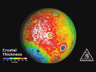
English: This image depicting the crustal thickness of the moon was derived using gravity data from NASA's GRAIL mission and topography data from NASA's Lunar Reconnaissance Orbiter. The measurements match those found from seismic data at the NASA Apollo mission 12 and 14 landing sites, where crustal thickness is 19 miles (30 kilometres). There is a minimum crustal thickness less than 0.6 mile (1 kilometre) within the nearside Crisium and far side Moscoviense impact basins. The average thickness of the crust is 21 miles (34 kilometers), which is almost 12 miles (20 kilometres) thinner than values from previous studies.
Regions of crustal thinning in blue are associated with several large impact basins several hundreds of kilometres in diameter. The far side differs from the near side by having a higher than average crustal thickness (in red). |
| Date | |
| Source | Map of Moon's Crust |
| Author | NASA/JPL-Caltech/MIT/GSFC |
Licensing[edit]
| This file is in the public domain in the United States because it was solely created by NASA. NASA copyright policy states that "NASA material is not protected by copyright unless noted". (See Template:PD-USGov, NASA copyright policy page or JPL Image Use Policy.) | ||
 |
Warnings:
|
File history
Click on a date/time to view the file as it appeared at that time.
| Date/Time | Thumbnail | Dimensions | User | Comment | |
|---|---|---|---|---|---|
| current | 23:04, 6 December 2012 | | 2,343 × 1,757 (806 KB) | Spideog (talk | contribs) | User created page with UploadWizard |
You cannot overwrite this file.
File usage on Commons
There are no pages that use this file.
File usage on other wikis
The following other wikis use this file:
- Usage on de.wikipedia.org
- Usage on gl.wikipedia.org
- Usage on lb.wikipedia.org