File:Map of the Gaza Strip (including checkpoints).svg
Jump to navigation
Jump to search

Size of this PNG preview of this SVG file: 512 × 347 pixels. Other resolutions: 320 × 217 pixels | 640 × 434 pixels | 1,024 × 694 pixels | 1,280 × 868 pixels | 2,560 × 1,735 pixels.
Original file (SVG file, nominally 512 × 347 pixels, file size: 143 KB)
Captions
Captions
Add a one-line explanation of what this file represents
Summary[edit]
.svg&action=edit§ion=1)
| Title |
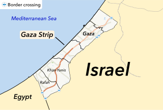
Map of the Gaza Strip |
| Description |
Map of the Gaza Strip, including border crossings. |
| SVG development | This map was created with Adobe Illustrator. |
| Date | |
| Source | OpenStreetMap contributors via [1], UN OCHA, ArcGIS icons which fall under TOO |
| Creator | |
| Permission (Reusing this file) |
This file is licensed under the Creative Commons Attribution-Share Alike 2.0 Generic license.
|
| Geotemporal data | |
| Map location | Gaza Strip |
| Spatial reference system | WGS84 |
| Archival data | |
| Notes |
Made with ArcGIS and Adobe Illustrator, projections are:
|
File history
Click on a date/time to view the file as it appeared at that time.
| Date/Time | Thumbnail | Dimensions | User | Comment | |
|---|---|---|---|---|---|
| current | 19:11, 14 May 2021 | | 512 × 347 (143 KB) | Isochrone (talk | contribs) | Scoured |
| 19:00, 14 May 2021 |  | 512 × 347 (178 KB) | Isochrone (talk | contribs) | please god | |
| 18:56, 14 May 2021 |  | 735 × 523 (160 KB) | Isochrone (talk | contribs) | fix | |
| 18:48, 14 May 2021 |  | 512 × 347 (180 KB) | Isochrone (talk | contribs) | {{Map |title = Map of the Gaza Strip |description = Map of the Gaza Strip, including border crossings. |author = {{u|Berrely}} |date = 14 May 2021 |source = OpenStreetMap contributors via [https://download.geofabrik.de/asia/israel-and-palestine.html], [https://data.humdata.org UN OCHA], ArcGIS icons which fall under TOO |permission = {{cc-by-sa-2.0}} |location = {{w|Gaza Strip}} |projection = WGS84 |warp... |
You cannot overwrite this file.
File usage on Commons
The following page uses this file:
- File:Map final.svg (file redirect)
File usage on other wikis
The following other wikis use this file:
- Usage on en.wikipedia.org
.svg&oldid=781477678)