File:Map of the Imperial Circles (1560)-de.svg
Jump to navigation
Jump to search

Size of this PNG preview of this SVG file: 614 × 599 pixels. Other resolutions: 246 × 240 pixels | 492 × 480 pixels | 787 × 768 pixels | 1,049 × 1,024 pixels | 2,098 × 2,048 pixels | 708 × 691 pixels.
Original file (SVG file, nominally 708 × 691 pixels, file size: 149 KB)
Captions
Captions
Add a one-line explanation of what this file represents
Summary[edit]
| Description |
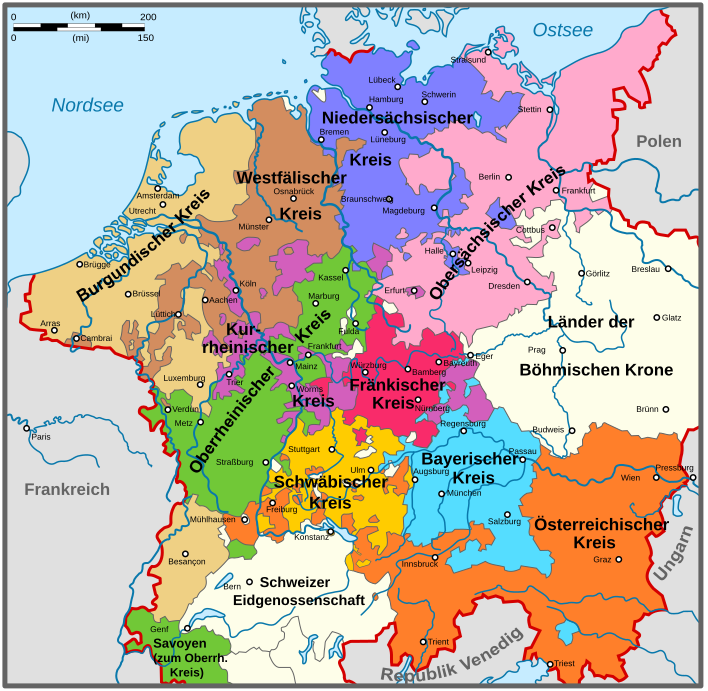
Nederlands: Kaart van de Kreitsen na de Transactie van Augsburg (1548). Duitse versie. English: Map of the Imperial Circles after the Transaction of Augsburg (1548). German version. |
| Date | (UTC) |
| Source | |
| Author |
|
| Other versions |
[] 1512[edit]
1560[edit]
|
-bg.png)
-de.png)
-en.png)
-fr.svg)
.png)
-de.svg)
-en.svg)
-es.svg)
-la.svg)
-nl.svg)
-de.svg&action=edit§ion=1)
-EN.svg)
| This is a retouched picture, which means that it has been digitally altered from its original version. Modifications: Deutsche Übersetzung. The original can be viewed here: Map of the Imperial Circles (1560)-en.svg:
|
Licensing[edit]
-de.svg&action=edit§ion=2)
I, the copyright holder of this work, hereby publish it under the following licenses:
This file is licensed under the Creative Commons Attribution-Share Alike 3.0 Unported license.
- You are free:
- to share – to copy, distribute and transmit the work
- to remix – to adapt the work
- Under the following conditions:
- attribution – You must give appropriate credit, provide a link to the license, and indicate if changes were made. You may do so in any reasonable manner, but not in any way that suggests the licensor endorses you or your use.
- share alike – If you remix, transform, or build upon the material, you must distribute your contributions under the same or compatible license as the original.

|
Permission is granted to copy, distribute and/or modify this document under the terms of the GNU Free Documentation License, Version 1.2 or any later version published by the Free Software Foundation; with no Invariant Sections, no Front-Cover Texts, and no Back-Cover Texts. A copy of the license is included in the section entitled GNU Free Documentation License. |
You may select the license of your choice.
Original upload log[edit]
-de.svg&action=edit§ion=3)
This image is a derivative work of the following images:
- File:Map_of_the_Imperial_Circles_(1560)-EN.svg licensed with Cc-by-sa-3.0, GFDL
- 2010-08-14T16:34:12Z Sir Iain 1165x1140 (344059 Bytes) The upper-Palatinate was actually part of the Electoral Rhenish Circle, contrary to almost all of the existing maps.
- 2010-06-29T10:42:00Z Sir Iain 1165x1140 (339935 Bytes) Changed text on path to objects. Text on path wouldn't display correctly.
- 2010-06-29T10:37:34Z Sir Iain 1165x1140 (285764 Bytes) {{Information |Description={{en|1=Map of the Imperial Circles after the Transaction of Augsburg (1548). English version.}} {{nl|1=Kaart van de Kreitsen na de Transactie van Augsburg (1548). Engelse versie.}} |Source={{own}} |
Uploaded with derivativeFX
File history
Click on a date/time to view the file as it appeared at that time.
| Date/Time | Thumbnail | Dimensions | User | Comment | |
|---|---|---|---|---|---|
| current | 22:07, 31 May 2020 | | 708 × 691 (149 KB) | Furfur (talk | contribs) | Schrift, Farben |
| 21:55, 31 May 2020 |  | 708 × 691 (152 KB) | Furfur (talk | contribs) | Schrift | |
| 21:52, 31 May 2020 |  | 708 × 691 (152 KB) | Furfur (talk | contribs) | Vorarlberg, Liechtenstein, Tarasp | |
| 17:31, 25 December 2011 |  | 708 × 691 (825 KB) | Furfur (talk | contribs) | reverted to original version, see User_talk:Furfur#Oberpfalz, Bavarian Circle | |
| 12:45, 24 December 2011 |  | 708 × 691 (829 KB) | Furfur (talk | contribs) | die Oberpfalz gehörte zum Bayerischen Reichskreis | |
| 20:52, 23 December 2011 |  | 708 × 691 (831 KB) | Furfur (talk | contribs) | == {{int:filedesc}} == {{Information |Description={{de|1=Karte der Reichskreise nach der Reichsreform Maximlilians I..}} {{nl|1=Kaart van de Kreitsen na de Transactie van Augsbur |
You cannot overwrite this file.
File usage on Commons
The following 13 pages use this file:
- User:Magog the Ogre/Multilingual legend/2020 May 21-31
- File:Map of the Imperial Circles (1512)-bg.png
- File:Map of the Imperial Circles (1512)-de.png
- File:Map of the Imperial Circles (1512)-en.png
- File:Map of the Imperial Circles (1512)-fr.svg
- File:Map of the Imperial Circles (1560)-de.svg
- File:Map of the Imperial Circles (1560)-en.svg
- File:Map of the Imperial Circles (1560)-es.svg
- File:Map of the Imperial Circles (1560)-la.svg
- File:Map of the Imperial Circles (1560)-nl.svg
- File:Német-római Birodalom körzetei (1512).png
- File:Reichkreise.svg (file redirect)
- Template:Other versions/Map of the Imperial Circles
File usage on other wikis
The following other wikis use this file:
- Usage on als.wikipedia.org
- Usage on bg.wikipedia.org
- Usage on ca.wikipedia.org
- Usage on de.wikipedia.org
- 1512
- 1560
- Reichstage zu Augsburg
- Ostbelgien
- Reichskreis
- Herzogtum Bar
- Obersachsen
- Isenburg (Adelsgeschlecht)
- Reichsreform (Heiliges Römisches Reich)
- Geschichte des Elsass
- Burgundischer Vertrag
- Landsmannschaft (Frühe Neuzeit)
- Kreisassoziation
- Ysenburg-Büdingen-Meerholz
- Ysenburg-Büdingen-Marienborn
- Sächsischer Reichskreis
- Ysenburg-Büdingen-Büdingen
- Ysenburg-Büdingen-Wächtersbach
- Usage on de.wikisource.org
- Usage on eo.wikipedia.org
- Usage on ja.wikipedia.org
- Usage on ka.wikipedia.org
- Usage on ro.wikipedia.org
- Usage on ru.wikipedia.org
- Usage on sv.wikipedia.org
-de.svg&oldid=638024593)