File:Mapa - Paises voseantes v2.png
Jump to navigation
Jump to search
Size of this preview: 800 × 351 pixels. Other resolutions: 320 × 140 pixels | 640 × 281 pixels | 1,425 × 625 pixels.
Original file (1,425 × 625 pixels, file size: 40 KB, MIME type: image/png)
Captions
Captions
Add a one-line explanation of what this file represents
| Description |
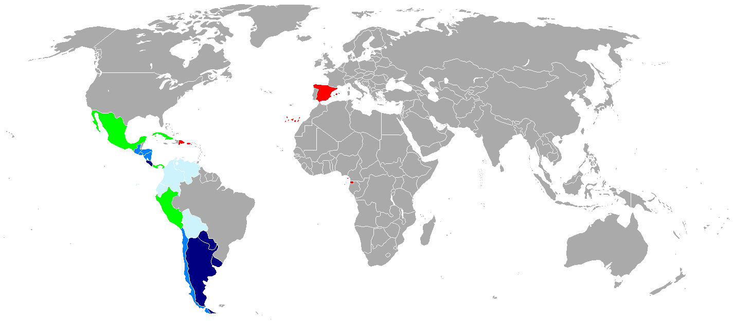
English: Map of countries with voseo. In dark blue and blue, countries with voseo predominance. In sky blue, countries where it is featured as a regionalism. In green, countries where is almost unused. In red, countries where only exists tuteo. Español: Mapa del voseo en Latinoamérica. En azul oscuro y azul claro países donde predomina completamente sobre el voseo; en celeste, países en que es un fenómeno regional; en verde, aquellos países en que casi no se usa; y en rojo, países donde sólo hay tuteo. |
| Date | (UTC) |
| Source | |
| Author |
|
| This is a retouched picture, which means that it has been digitally altered from its original version. Modifications: Change sky blue for green, and vice versa. Costa Rica coloured dark blue (according to the RAE data).. The original can be viewed here: Mapa - Paises voseantes.png:
|
I, the copyright holder of this work, hereby publish it under the following license:
This file is licensed under the Creative Commons Attribution-Share Alike 2.5 Generic license.
- You are free:
- to share – to copy, distribute and transmit the work
- to remix – to adapt the work
- Under the following conditions:
- attribution – You must give appropriate credit, provide a link to the license, and indicate if changes were made. You may do so in any reasonable manner, but not in any way that suggests the licensor endorses you or your use.
- share alike – If you remix, transform, or build upon the material, you must distribute your contributions under the same or compatible license as the original.
Original upload log
[edit]
This image is a derivative work of the following images:
- File:Mapa_-_Paises_voseantes.png licensed with Cc-by-sa-2.5
- 2009-12-14T04:58:48Z House1090 402x450 (36825 Bytes) Medium Blue to Dark Blue (El Salvador), vos is used, as a Salvadoran I have never heard any salvadoran say "tu" nor ever wrote/write tu. Salvadoran signs are written in voseo, not in tu.
- 2009-05-30T21:48:57Z Lin linao 402x450 (36859 Bytes) Marginal en Perú.
- 2009-04-04T04:46:40Z Ositoster 402x450 (36387 Bytes) Changing Costa Rica from middle blue to dark blue.
- 2009-02-04T10:38:39Z Wikinv 402x450 (38916 Bytes)
- 2008-06-14T03:01:52Z Lin linao 402x450 (36859 Bytes)
- 2008-06-12T19:46:49Z Lin linao 402x450 (36944 Bytes) {{Information |Description={{es|Mapa del [[:es:voseo|voseo]] en Latinoamérica. En azul oscuro, países donde no se usa el tuteo, en azul, países donde voseo y tuteo coexisten, en verde, países en que el voseo existe en alg
- 2008-06-11T20:24:51Z Cookie 402x450 (23262 Bytes) Reverted to version as of 05:00, 6 June 2008, preferably a blank map to put the appropriate footnotes
- 2008-06-09T18:13:20Z El bart089 402x450 (10221 Bytes) Reverted to version as of 01:46, 4 June 2008
- 2008-06-06T05:00:56Z Neutre 402x450 (23262 Bytes) Reverted to version as of 15:47, 27 May 2008
- 2008-06-04T01:46:08Z El bart089 402x450 (10221 Bytes) Updated version with colour description.
- 2008-05-27T15:47:44Z Lin linao 402x450 (23262 Bytes)
- 2006-10-05T07:43:37Z SpiceMan 402x450 (23591 Bytes) {{Information |Description=Mapa de los países voseantes |Source=[[Image:Map-Latin-America2.png]] and [[Image:800px-BlankMap-World-v6.png]] |Date=5-oct-2006 |Author=Marcel Montes |Permission= |other_versions= }} * '''es''':
Uploaded with derivativeFX
File history
Click on a date/time to view the file as it appeared at that time.
| Date/Time | Thumbnail | Dimensions | User | Comment | |
|---|---|---|---|---|---|
| current | 16:51, 28 March 2018 | | 1,425 × 625 (40 KB) | Maphobbyist (talk | contribs) | Update |
| 17:13, 6 March 2018 |  | 1,425 × 625 (40 KB) | Maphobbyist (talk | contribs) | South Sudan border | |
| 03:02, 8 April 2010 |  | 1,425 × 625 (57 KB) | Iñaki Salazar (talk | contribs) | Actualización | |
| 23:14, 4 April 2010 |  | 402 × 450 (36 KB) | Iñaki Salazar (talk | contribs) | Changing El Salvador from dark blue to middle blue. | |
| 23:12, 4 April 2010 |  | 402 × 450 (36 KB) | Iñaki Salazar (talk | contribs) | Changing El Salvador from dark blue to middle blue. | |
| 23:09, 4 April 2010 |  | 402 × 450 (36 KB) | Iñaki Salazar (talk | contribs) | Reverted to version as of 02:10, 4 April 2010 | |
| 23:08, 4 April 2010 |  | 402 × 450 (36 KB) | Iñaki Salazar (talk | contribs) | The color was changed to El Salvador to blue. | |
| 02:10, 4 April 2010 |  | 402 × 450 (36 KB) | Iñaki Salazar (talk | contribs) | {{Information |Description={{en|Map of countries with voseo. In dark blue and blue, countries with voseo predominance. In sky blue, countries where it is featured as a regionalism. In green, countries where is almost unused. In red, countrie |
You cannot overwrite this file.
File usage on Commons
The following 2 pages use this file:
File usage on other wikis
The following other wikis use this file:
- Usage on es.wikipedia.org