File:Mapa Cordón del Caulle Area de Dispersion 23d.png
Jump to navigation
Jump to search

Size of this preview: 800 × 435 pixels. Other resolutions: 320 × 174 pixels | 640 × 348 pixels | 1,217 × 661 pixels.
Original file (1,217 × 661 pixels, file size: 397 KB, MIME type: image/png)
Captions
Captions
Add a one-line explanation of what this file represents
Summary[edit]
| Description |
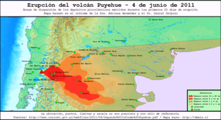
Español: Áreas de dispersión, espesor de los depósitos y tamaño de los piroclastos emitidos durante los primeros 23 días de erupción por el complejo volcánico Puyehue-Cordón del Caulle. |
| Date | |
| Source | Own work. Para el mapa base utilicé el mapa de Demis.nl: Map of Argentina Demis.png. Datos basados en el informe publicado por la Dra. Adriana Bermúdez y el Dr. Daniel Delpino aquí. |
| Author | Arcibel |
| Camera location | | View this and other nearby images on: OpenStreetMap |
|---|
Licensing[edit]
I, the copyright holder of this work, hereby publish it under the following license:
This file is licensed under the Creative Commons Attribution-Share Alike 3.0 Unported license.
- You are free:
- to share – to copy, distribute and transmit the work
- to remix – to adapt the work
- Under the following conditions:
- attribution – You must give appropriate credit, provide a link to the license, and indicate if changes were made. You may do so in any reasonable manner, but not in any way that suggests the licensor endorses you or your use.
- share alike – If you remix, transform, or build upon the material, you must distribute your contributions under the same or compatible license as the original.
File history
Click on a date/time to view the file as it appeared at that time.
| Date/Time | Thumbnail | Dimensions | User | Comment | |
|---|---|---|---|---|---|
| current | 23:56, 25 July 2011 | | 1,217 × 661 (397 KB) | Arcibel (talk | contribs) | Mayor resolución |
| 23:52, 25 July 2011 |  | 800 × 433 (424 KB) | Arcibel (talk | contribs) | Se corrigieron nombres de lugares | |
| 23:01, 15 July 2011 |  | 1,222 × 662 (674 KB) | Arcibel (talk | contribs) | {{Information |Description ={{es|1=Áreas de dispersión, espesor de los depósitos y tamaño de los piroclastos emitidos durante los primeros 23 días de erupción por el complejo volcánico Puyehue-Cordón del Caulle.}} |Source ={{own}}. Para |
You cannot overwrite this file.
File usage on Commons
The following page uses this file:
File usage on other wikis
The following other wikis use this file:
- Usage on es.wikipedia.org