File:Mapa Region Sierra de Amula Jalisco.svg
Jump to navigation
Jump to search

Size of this PNG preview of this SVG file: 400 × 553 pixels. Other resolutions: 173 × 240 pixels | 347 × 480 pixels | 555 × 768 pixels | 741 × 1,024 pixels | 1,481 × 2,048 pixels.
Original file (SVG file, nominally 400 × 553 pixels, file size: 21 KB)
Captions
Captions
Add a one-line explanation of what this file represents
Summary[edit]
| Description |
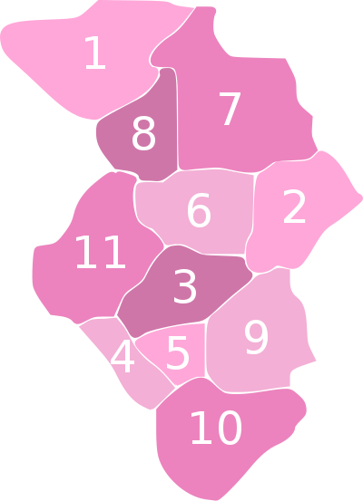
Español: Mapa de la Región Altos Sur del Estado de Jalisco, México, donde los números representan, respectivamente, a los siguientes municipios:
|
| Date | |
| Source | Own work |
| Author | Jpablo cad |
Licensing[edit]
I, the copyright holder of this work, hereby publish it under the following license:
This file is licensed under the Creative Commons Attribution 3.0 Unported license.
- You are free:
- to share – to copy, distribute and transmit the work
- to remix – to adapt the work
- Under the following conditions:
- attribution – You must give appropriate credit, provide a link to the license, and indicate if changes were made. You may do so in any reasonable manner, but not in any way that suggests the licensor endorses you or your use.
File history
Click on a date/time to view the file as it appeared at that time.
| Date/Time | Thumbnail | Dimensions | User | Comment | |
|---|---|---|---|---|---|
| current | 00:15, 5 October 2008 | | 400 × 553 (21 KB) | Jpablo cad (talk | contribs) | {{Information |Description={{es|1=Español: Mapa de la Región Altos Sur del Estado de Jalisco, México, donde los números representan, respectivamente, a los siguientes municipios: #Atengo #Chiquilistlán #Ejutla #El Grullo #El Limón #Juchitlán |
You cannot overwrite this file.
File usage on Commons
There are no pages that use this file.
File usage on other wikis
The following other wikis use this file:
- Usage on es.wikipedia.org