File:Mapa da crescente fértil.png
Jump to navigation
Jump to search
Size of this preview: 466 × 599 pixels. Other resolutions: 187 × 240 pixels | 373 × 480 pixels | 825 × 1,060 pixels.
Original file (825 × 1,060 pixels, file size: 185 KB, MIME type: image/png)
Captions
Captions
Add a one-line explanation of what this file represents
Summary[edit]
| Description |
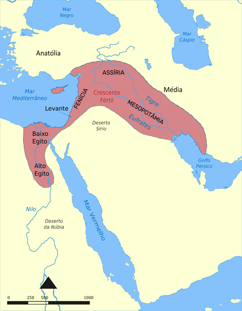
Português: Este mapa mostra a localização e a extensão do Crescente Fértil, uma região do Oriente Médio que incorpora o Egito Antigo, o Levante e a Mesopotâmia. |
| Date | |
| Source |
This file was derived from: Fertile Crescent map.png:  |
| Author |
|
| Other versions |
[]
See also:
|


| This is a retouched picture, which means that it has been digitally altered from its original version. Modifications: Translated to portuguese. The original can be viewed here: Fertile Crescent map.png:
|
Licensing[edit]
I, the copyright holder of this work, hereby publish it under the following license:
This file is licensed under the Creative Commons Attribution-Share Alike 4.0 International license.
- You are free:
- to share – to copy, distribute and transmit the work
- to remix – to adapt the work
- Under the following conditions:
- attribution – You must give appropriate credit, provide a link to the license, and indicate if changes were made. You may do so in any reasonable manner, but not in any way that suggests the licensor endorses you or your use.
- share alike – If you remix, transform, or build upon the material, you must distribute your contributions under the same or compatible license as the original.
File history
Click on a date/time to view the file as it appeared at that time.
| Date/Time | Thumbnail | Dimensions | User | Comment | |
|---|---|---|---|---|---|
| current | 02:34, 10 November 2021 | | 825 × 1,060 (185 KB) | Parzeus (talk | contribs) | Uploaded own work with UploadWizard |
You cannot overwrite this file.
File usage on Commons
The following 9 pages use this file:
- User:Magog the Ogre/Multilingual legend/2021 November 1-10
- File:Croissant fertile carte.png
- File:Fertile Crescent map.png
- File:Fertile Crescent map it.PNG
- File:Ilgora Emankorraren mapa.png
- File:Mapa da crescente fértil.png
- File:Mapa del Creciente Fértil.png
- File:Mapa do Crecente Fertil en galego.png
- Template:Other versions/Fertile Crescent map
File usage on other wikis
The following other wikis use this file:
- Usage on pt.wikipedia.org