File:Mappa delle nuove province d'Italia, dal 1992 - Map of the new provinces of Italy, since 1992.png
Jump to navigation
Jump to search

Size of this preview: 468 × 599 pixels. Other resolutions: 187 × 240 pixels | 375 × 480 pixels | 600 × 768 pixels | 800 × 1,024 pixels | 1,600 × 2,048 pixels | 5,300 × 6,785 pixels.
Original file (5,300 × 6,785 pixels, file size: 2.71 MB, MIME type: image/png)
Captions
Captions
Add a one-line explanation of what this file represents
Summary[edit]
| Description |
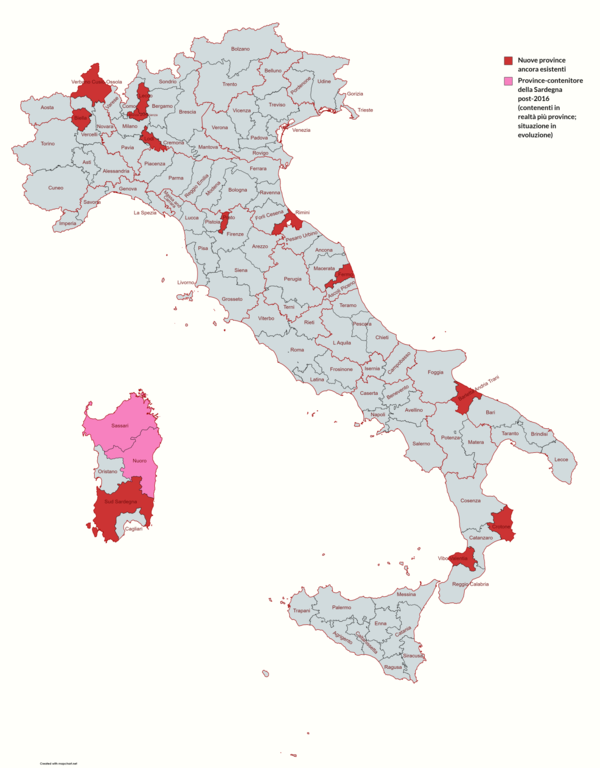
Italiano: Mappa delle nuove province d'Italia, dal 1992.
Mappa creata con MapChart.net Per la Sardegna si tiene conto della riforma della Sardegna del 2016 che ha 'soppresso' alcune province nascondendole in quelle maggiori. Alcune di queste province nascoste sono, tra l'altro, in corso di re-istituzione dal 2021. |
| Date | |
| Source | https://www.mapchart.net/italy.html |
| Author | MapChart.net & User:LucaLindholm |
Licensing[edit]
This file is licensed under the Creative Commons Attribution-Share Alike 4.0 International license.
- You are free:
- to share – to copy, distribute and transmit the work
- to remix – to adapt the work
- Under the following conditions:
- attribution – You must give appropriate credit, provide a link to the license, and indicate if changes were made. You may do so in any reasonable manner, but not in any way that suggests the licensor endorses you or your use.
- share alike – If you remix, transform, or build upon the material, you must distribute your contributions under the same or compatible license as the original.
File history
Click on a date/time to view the file as it appeared at that time.
| Date/Time | Thumbnail | Dimensions | User | Comment | |
|---|---|---|---|---|---|
| current | 09:00, 1 May 2023 | | 5,300 × 6,785 (2.71 MB) | LucaLindholm (talk | contribs) | Uploaded a work by MapChart.net & User:LucaLindholm from https://www.mapchart.net/italy.html with UploadWizard |
You cannot overwrite this file.
File usage on Commons
There are no pages that use this file.
File usage on other wikis
The following other wikis use this file:
- Usage on it.wikipedia.org