File:Marburg Stadtteilkarte.jpg
Jump to navigation
Jump to search

Size of this preview: 629 × 599 pixels. Other resolutions: 252 × 240 pixels | 504 × 480 pixels | 806 × 768 pixels | 1,075 × 1,024 pixels | 2,149 × 2,048 pixels | 4,598 × 4,382 pixels.
Original file (4,598 × 4,382 pixels, file size: 3.74 MB, MIME type: image/jpeg)
Captions
Captions
Add a one-line explanation of what this file represents
Summary[edit]
| Description |
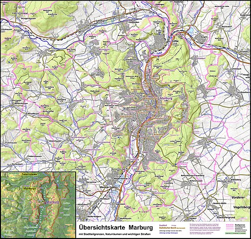
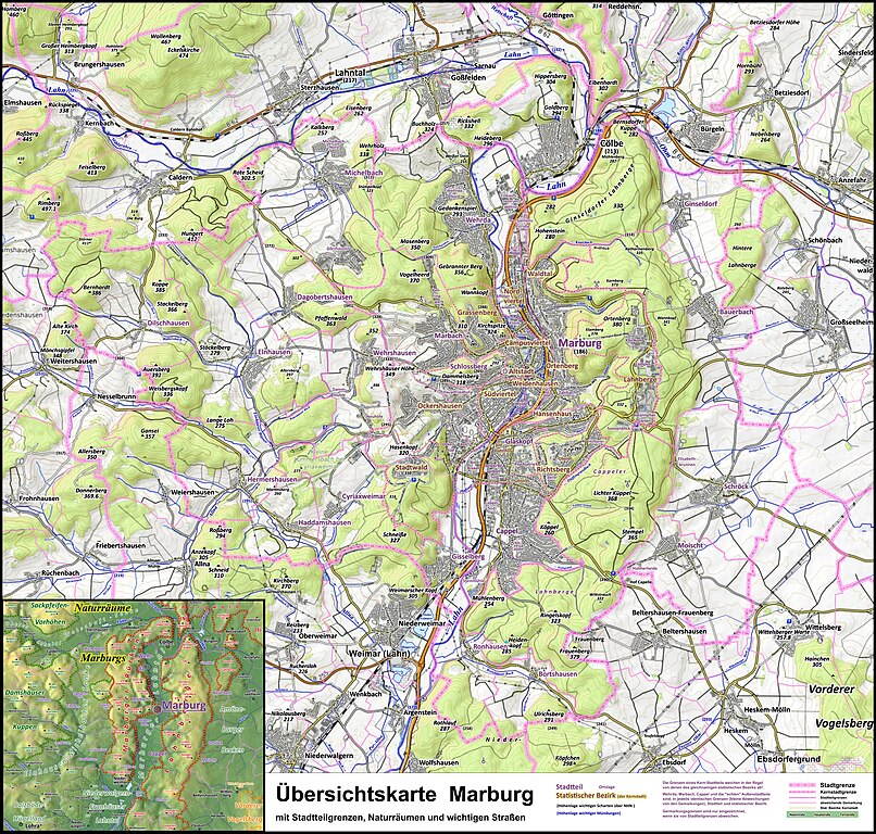
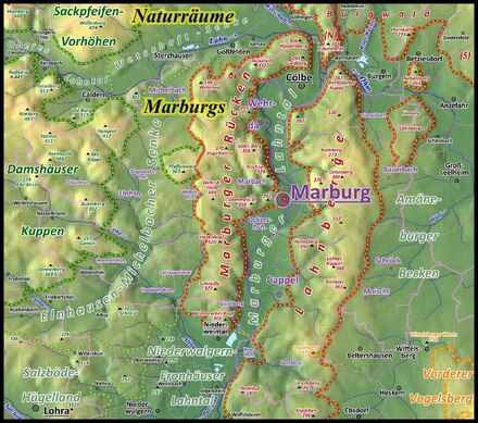
Deutsch: Topographische Karte zur Stadtgliederung Marburgs. Legende: Gemarkungsgrenze der Stadt Marburg im Landkreis Marburg-Biedenkopf: ... , Abgrenzung der Stadtteile: ... mit gelb unterlegter Beschriftung, Statistische Bezirke: ... gestrichelte Linie aus gelben Punkten. English: Map of Marburg with city districts. Map symbols: |
| Date | |
| Source | Own work / Gemarkungsgrenzen aus dem Geologieviewer HE (Hinweise), https://www.marburg.de/medien/dokumente/strassenverzeichnis_stadtteile_der_kernstadt_nach_strassennummern_stand_februar_2020_.pdf?20200715140943 |
| Author | Elop, Background: OpenTopoMap, OTM-Kacheln vom 17.08.2021 |
| Other versions |
   |
Licensing[edit]
I, the copyright holder of this work, hereby publish it under the following license:
This file is licensed under the Creative Commons Attribution-Share Alike 3.0 Unported license.
- You are free:
- to share – to copy, distribute and transmit the work
- to remix – to adapt the work
- Under the following conditions:
- attribution – You must give appropriate credit, provide a link to the license, and indicate if changes were made. You may do so in any reasonable manner, but not in any way that suggests the licensor endorses you or your use.
- share alike – If you remix, transform, or build upon the material, you must distribute your contributions under the same or compatible license as the original.
File history
Click on a date/time to view the file as it appeared at that time.
| Date/Time | Thumbnail | Dimensions | User | Comment | |
|---|---|---|---|---|---|
| current | 12:23, 7 September 2021 | | 4,598 × 4,382 (3.74 MB) | Elop (talk | contribs) | |
| 14:35, 3 September 2021 |  | 4,598 × 4,382 (3.68 MB) | Elop (talk | contribs) | ||
| 14:59, 29 August 2021 |  | 4,598 × 4,382 (3.65 MB) | Elop (talk | contribs) | + Grenzen der Nachbargemeinden zueinander | |
| 22:29, 26 August 2021 |  | 4,598 × 4,382 (3.6 MB) | Elop (talk | contribs) | (Schrift in Naturraumkarte 80 %, dafür alles beschriftet) | |
| 18:30, 26 August 2021 |  | 4,598 × 4,382 (3.58 MB) | Elop (talk | contribs) | mehr Details, Naturraumgrenzen raus | |
| 18:09, 24 August 2021 |  | 4,598 × 4,382 (3.53 MB) | Elop (talk | contribs) | +Naturräume | |
| 15:14, 22 August 2021 |  | 4,598 × 4,068 (3.28 MB) | Elop (talk | contribs) | Berge, Scharten, Gewässerhöhen | |
| 14:53, 20 August 2021 |  | 4,598 × 4,068 (3.13 MB) | Elop (talk | contribs) | vor alle im Bereich Ockershausen/Stadtwald Details | |
| 20:10, 19 August 2021 |  | 4,598 × 4,068 (3.12 MB) | Elop (talk | contribs) | k | |
| 13:03, 19 August 2021 |  | 4,598 × 4,068 (3.11 MB) | Elop (talk | contribs) | + Grenzen der stat. Bezirke |
You cannot overwrite this file.
File usage on Commons
The following 7 pages use this file:
File usage on other wikis
The following other wikis use this file:
- Usage on de.wikipedia.org