File:Mauryan Empire Map-zh-classical.png
Jump to navigation
Jump to search
No higher resolution available.
Mauryan_Empire_Map-zh-classical.png (400 × 337 pixels, file size: 10 KB, MIME type: image/png)
Captions
Captions
Add a one-line explanation of what this file represents

|
This historical map image could be re-created using vector graphics as an SVG file. This has several advantages; see Commons:Media for cleanup for more information. If an SVG form of this image is available, please upload it and afterwards replace this template with
{{vector version available|new image name}}.
It is recommended to name the SVG file “Mauryan Empire Map-zh-classical.svg”—then the template Vector version available (or Vva) does not need the new image name parameter. |

|
This map has been uploaded by Electionworld from en.wikipedia.org to enable the |
Summary[edit]
| Description |
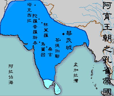
English: A political map of the Mauryan Empire, including notable cities, such as the capital Pataliputra, and site of the Buddha's enlightenment.
Original picture was uploaded here.
The Classical Chinese Modification is made by User:Itsmine. |
| Date | File was made on August 3, 2006, using Microsoft Paint. |
| Source | Based upon common poltical maps of the Mauryan Empire, created from this template: Image:Marathas.GIF |
| Author |
Licensing[edit]
| This work has been released into the public domain by its author, Vastu. This applies worldwide. In some countries this may not be legally possible; if so: |
File history
Click on a date/time to view the file as it appeared at that time.
| Date/Time | Thumbnail | Dimensions | User | Comment | |
|---|---|---|---|---|---|
| current | 08:41, 12 May 2007 | | 400 × 337 (10 KB) | Itsmine (talk | contribs) | {{ew|en|Vastu}} {{ShouldBeSVG|map}} ==Description== A poltical map of the Mauryan Empire, including notable cities, such as the capital Pataliputra, and site of the Buddha's enlightenment. Original picture was uploaded [[:Image:Mauryan Emp |
You cannot overwrite this file.
File usage on Commons
The following page uses this file: