File:Mayotte topographic map-fr.svg
Jump to navigation
Jump to search

Size of this PNG preview of this SVG file: 477 × 599 pixels. Other resolutions: 191 × 240 pixels | 382 × 480 pixels | 612 × 768 pixels | 815 × 1,024 pixels | 1,631 × 2,048 pixels | 1,033 × 1,297 pixels.
Original file (SVG file, nominally 1,033 × 1,297 pixels, file size: 874 KB)
Captions
Captions
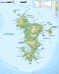
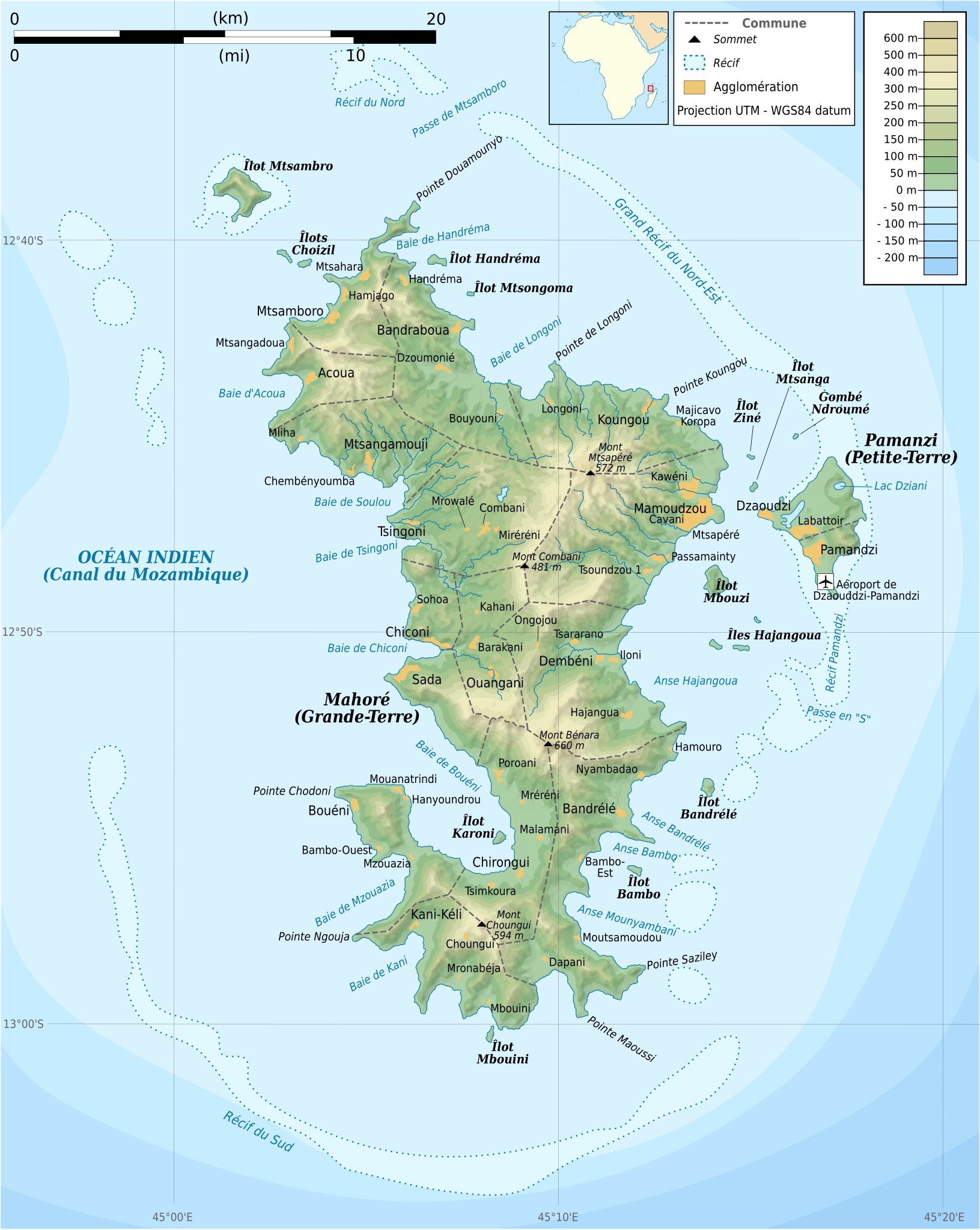
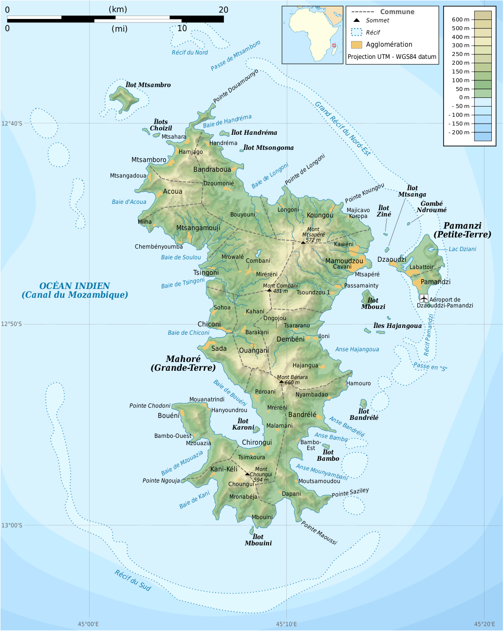
Mayotte topographic map by Remi Kaupp
Summary[edit]
| Description |
Français : Carte topographique de Mayotte en français. Utiliser la version PNG dans les articles pour un rendu plus rapide.
|
| Date | |
| Source |
Own work. Sources of data:
|
| Author | Rémi Kaupp |
| Other versions |
[]
|


English: This map has been created by Rémi Kaupp (User:Korrigan) and released under the license(s) stated below. You are free to use it for any purpose as long as you credit me and follow the terms of the license. You may need to credit the sources of data of the map (please check). Example:
Français : Cette carte a été créée par Rémi Kaupp (User:Korrigan) et placée sous la ou les licence(s) ci-dessous. Vous êtes libre de la réutiliser, tant que vous me citez en tant qu'auteur et suivez les instructions de la licence. Certaines sources de données de la carte doivent peut-être être créditées, veuillez vérifier. Exemple :
|
 |
Licensing[edit]
I, the copyright holder of this work, hereby publish it under the following licenses:

|
Permission is granted to copy, distribute and/or modify this document under the terms of the GNU Free Documentation License, Version 1.2 or any later version published by the Free Software Foundation; with no Invariant Sections, no Front-Cover Texts, and no Back-Cover Texts. A copy of the license is included in the section entitled GNU Free Documentation License. |
This file is licensed under the Creative Commons Attribution-Share Alike 4.0 International, 3.0 Unported, 2.5 Generic, 2.0 Generic and 1.0 Generic license.
- You are free:
- to share – to copy, distribute and transmit the work
- to remix – to adapt the work
- Under the following conditions:
- attribution – You must give appropriate credit, provide a link to the license, and indicate if changes were made. You may do so in any reasonable manner, but not in any way that suggests the licensor endorses you or your use.
- share alike – If you remix, transform, or build upon the material, you must distribute your contributions under the same or compatible license as the original.
You may select the license of your choice.
File history
Click on a date/time to view the file as it appeared at that time.
| Date/Time | Thumbnail | Dimensions | User | Comment | |
|---|---|---|---|---|---|
| current | 20:55, 24 March 2009 | | 1,033 × 1,297 (874 KB) | Korrigan (talk | contribs) | {{Information |Description={{en|Topographic map of Mayotte in French. Use the PNG version in articles for faster loading.}} {{fr|Carte topographique de Mayotte en français. Utiliser [[:File:Mayotte_topographic |
You cannot overwrite this file.
File usage on Commons
The following 44 pages use this file:
- Mayotte
- File:Mayotte administrative map-fr.png
- File:Mayotte administrative map-fr.svg
- File:Mayotte blank map.svg
- File:Mayotte communes map-fr.png
- File:Mayotte communes map-fr.svg
- File:Mayotte road map-fr.png
- File:Mayotte road map-fr.svg
- File:Mayotte topographic blank map.png
- File:Mayotte topographic blank map.svg
- File:Mayotte topographic map-de.svg
- File:Mayotte topographic map-fr.png
- File:Mayotte topographic map-fr.svg
- Template:Other versions/Maps of Mayotte
- Category:2004 in Mayotte
- Category:2007 in Mayotte
- Category:2008 in Mayotte
- Category:2013 in Mayotte
- Category:2018 in Mayotte
- Category:2019 in Mayotte
- Category:Airports in Mayotte
- Category:Animals of Mayotte
- Category:Births in Mayotte
- Category:Bodies of water in Mayotte
- Category:Buildings in Mayotte
- Category:Deaths in Mayotte
- Category:Groups of communes in Mayotte
- Category:Islands of Mayotte
- Category:Landforms of Mayotte
- Category:Mangroves in Mayotte
- Category:Maps of Mayotte
- Category:Mayotte
- Category:Mayotte by decade
- Category:Mayotte by year
- Category:Mayotte in the 2000s
- Category:Mayotte in the 2010s
- Category:Mosques in Mayotte
- Category:People of Mayotte
- Category:Populated places in Mayotte
- Category:Routes nationales in Mayotte
- Category:Town halls in Mayotte
- Category:Transport in Mayotte
- Category:Trees in Mayotte
- Category:Whale watching in Mayotte
File usage on other wikis
The following other wikis use this file:
- Usage on ar.wikipedia.org
- Usage on az.wikipedia.org
- Usage on br.wikipedia.org
- Usage on ca.wikipedia.org
- Usage on ce.wikipedia.org
- Usage on cs.wikipedia.org
- Usage on en.wikipedia.org
- Usage on es.wikipedia.org
- Usage on fr.wikipedia.org
- Usage on ga.wikipedia.org
- Usage on gl.wikipedia.org
- Usage on io.wikipedia.org
- Usage on is.wikipedia.org
- Usage on it.wikipedia.org
- Usage on ja.wikipedia.org
- Usage on la.wikipedia.org
- Usage on nl.wikipedia.org
- Usage on pl.wiktionary.org
- Usage on ru.wikipedia.org
- Usage on sc.wikipedia.org
- Usage on tt.wikipedia.org
- Usage on uk.wikipedia.org
- Usage on www.wikidata.org