File:Medieval map of Cairo.png
Jump to navigation
Jump to search
Size of this preview: 379 × 599 pixels. Other resolutions: 152 × 240 pixels | 303 × 480 pixels | 486 × 768 pixels | 648 × 1,024 pixels | 1,336 × 2,112 pixels.
Original file (1,336 × 2,112 pixels, file size: 298 KB, MIME type: image/png)
Captions
Captions
Add a one-line explanation of what this file represents
Summary
[edit]
| Description |
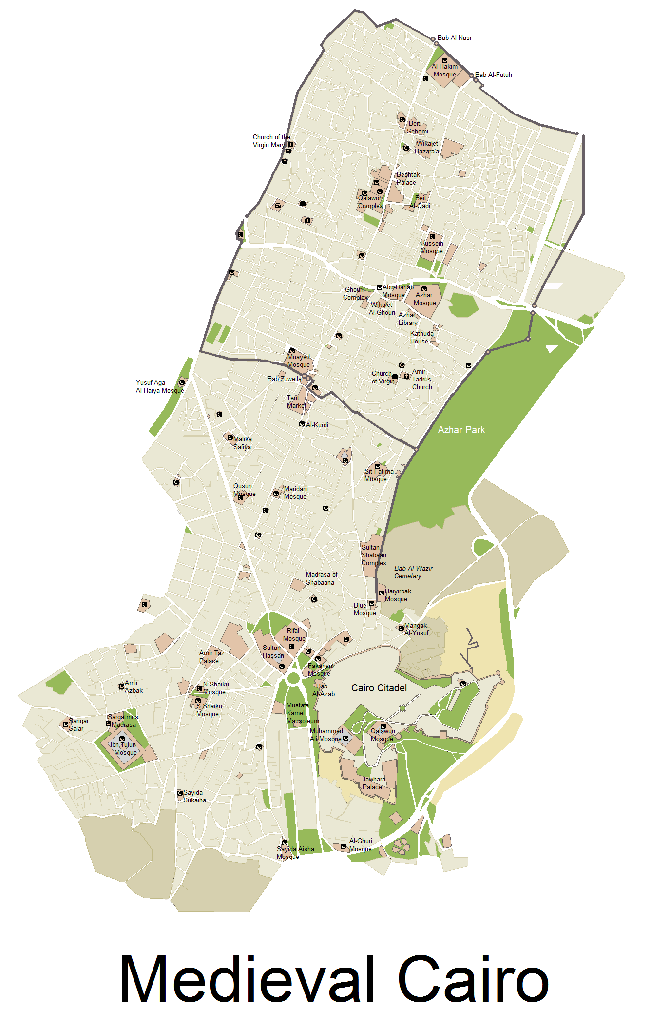
English: A Map showing the size of Medieval Cairo, with remaining Monuments today, map Includes Cairo from its establishing, till the late 17th century - NOTE: Bab Al-Futuh and Bab Al-Nasr are wrongly switched. See revised version here: https://commons.wikimedia.org/wiki/File:Medieval_map_of_Cairo_revised.png |
| Date | |
| Source |
i used several Print screens from a google map, and then worked on it via Microsoft paint, and then searched for boundries of the city, and location of monuments online. |
| Author | Arab Hafez |
Licensing
[edit]
I, the copyright holder of this work, hereby publish it under the following licenses:

|
Permission is granted to copy, distribute and/or modify this document under the terms of the GNU Free Documentation License, Version 1.2 or any later version published by the Free Software Foundation; with no Invariant Sections, no Front-Cover Texts, and no Back-Cover Texts. A copy of the license is included in the section entitled GNU Free Documentation License. |
This file is licensed under the Creative Commons Attribution-Share Alike 3.0 Unported license.
- You are free:
- to share – to copy, distribute and transmit the work
- to remix – to adapt the work
- Under the following conditions:
- attribution – You must give appropriate credit, provide a link to the license, and indicate if changes were made. You may do so in any reasonable manner, but not in any way that suggests the licensor endorses you or your use.
- share alike – If you remix, transform, or build upon the material, you must distribute your contributions under the same or compatible license as the original.
You may select the license of your choice.
File history
Click on a date/time to view the file as it appeared at that time.
| Date/Time | Thumbnail | Dimensions | User | Comment | |
|---|---|---|---|---|---|
| current | 00:01, 12 January 2018 | | 1,336 × 2,112 (298 KB) | SteinsplitterBot (talk | contribs) | Bot: Image rotated by 270° |
| 22:01, 11 November 2017 |  | 2,112 × 1,336 (321 KB) | SteinsplitterBot (talk | contribs) | Bot: Image rotated by 90° | |
| 14:42, 4 January 2013 |  | 1,336 × 2,112 (372 KB) | Arab Hafez (talk | contribs) | {{subst:Upload marker added by en.wp UW}} {{Information |Description = {{en|a Map showing the size of Medieval Cairo, with remaining Monuments today, map Includes Cairo from its establishing, till the late 17th century}} |Source = i used several Print ... |
You cannot overwrite this file.
File usage on Commons
The following page uses this file:
File usage on other wikis
The following other wikis use this file:
- Usage on de.wikipedia.org
- Usage on el.wikipedia.org
- Usage on en.wikipedia.org
- Usage on it.wikipedia.org
- Usage on mai.wikipedia.org
- Usage on vi.wikipedia.org
- Usage on www.wikidata.org