File:Melbourne trams map old.gif
Jump to navigation
Jump to search

Size of this preview: 609 × 599 pixels. Other resolutions: 244 × 240 pixels | 488 × 480 pixels | 781 × 768 pixels | 1,041 × 1,024 pixels | 2,370 × 2,332 pixels.
Original file (2,370 × 2,332 pixels, file size: 295 KB, MIME type: image/gif, 0.1 s)
Captions
Captions
Add a one-line explanation of what this file represents
Summary[edit]

|
This transport map image could be re-created using vector graphics as an SVG file. This has several advantages; see Commons:Media for cleanup for more information. If an SVG form of this image is available, please upload it and afterwards replace this template with
{{vector version available|new image name}}.
It is recommended to name the SVG file “Melbourne trams map old.svg”—then the template Vector version available (or Vva) does not need the new image name parameter. |
| Description |
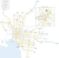
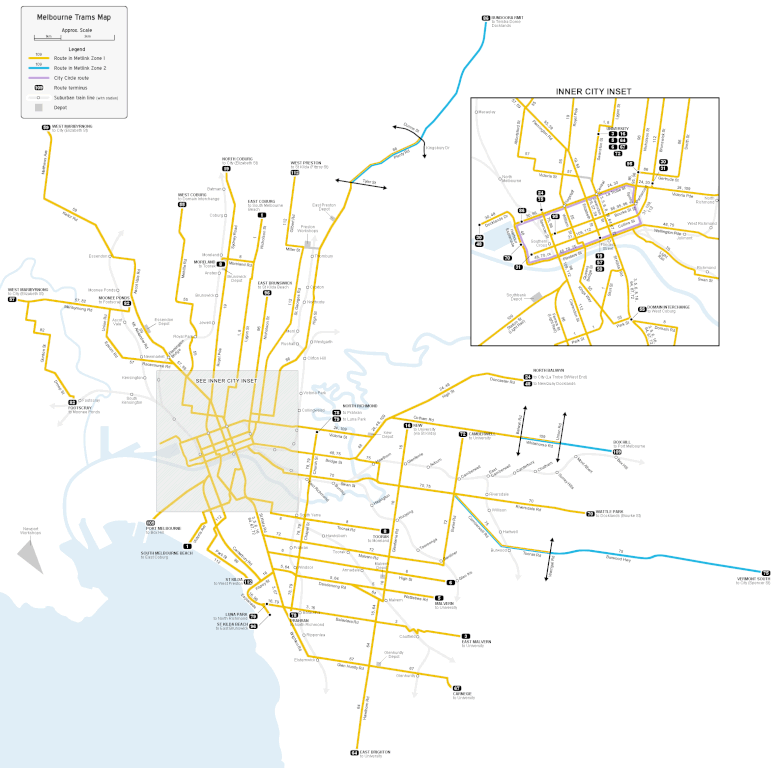
English: Map of Melbourne's tram network, geographically accurate, to approximate scale. |
| Date |
26 February 2008 (original upload date) |
| Source | Own work (Original text: self-made) |
| Author |
JohnnoShadbolt at English Wikipedia |
tree
Licensing[edit]
JohnnoShadbolt at English Wikipedia, the copyright holder of this work, hereby publishes it under the following license:
This file is licensed under the Creative Commons Attribution 3.0 Unported license.
Attribution: JohnnoShadbolt at English Wikipedia
- You are free:
- to share – to copy, distribute and transmit the work
- to remix – to adapt the work
- Under the following conditions:
- attribution – You must give appropriate credit, provide a link to the license, and indicate if changes were made. You may do so in any reasonable manner, but not in any way that suggests the licensor endorses you or your use.
Original upload log[edit]
The original description page was here. All following user names refer to en.wikipedia.
- 2008-02-26 05:26 JohnnoShadbolt 2370×2332×8 (301724 bytes) {{Information |Description=Map of [[Melbourne|Melbourne's]] tram network, geographically accurate, to approximate scale. |Source=self-made |Date=26th February, 2008 |Location= |Author=~~~ |other_versions= }}
File history
Click on a date/time to view the file as it appeared at that time.
| Date/Time | Thumbnail | Dimensions | User | Comment | |
|---|---|---|---|---|---|
| current | 19:59, 14 April 2008 | | 2,370 × 2,332 (295 KB) | File Upload Bot (Magnus Manske) (talk | contribs) | {{BotMoveToCommons|en.wikipedia}} {{Information |Description={{en|Map of Melbourne's tram network, geographically accurate, to approximate scale.}} |Source=Transferred from [http://en.wikipedia.org en.wikipedia]<br/> (Original text : '' |
You cannot overwrite this file.
File usage on Commons
There are no pages that use this file.
File usage on other wikis
The following other wikis use this file:
- Usage on en.wikipedia.org