File:Mercator-Hondius-1609-Ottoman Empire.jpg
Mercator-Hondius-1609-Ottoman_Empire.jpg (750 × 560 pixels, file size: 307 KB, MIME type: image/jpeg)
Captions
Captions
Summary[edit]
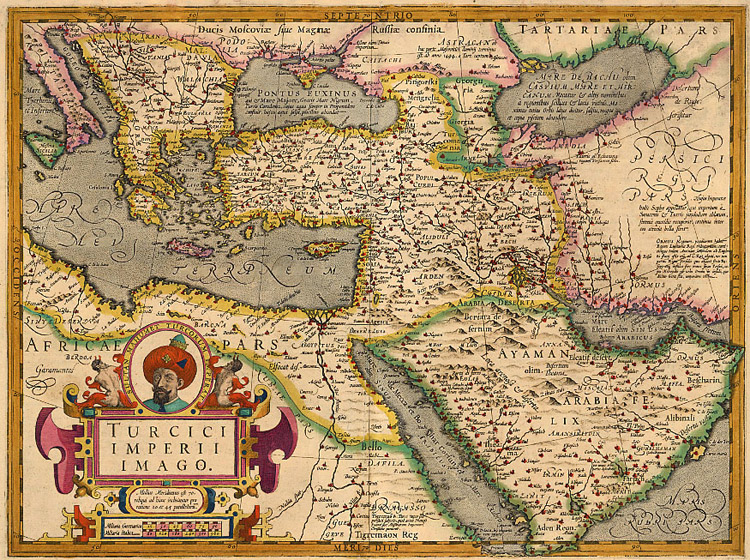
Map of the Ottoman Empire from the 1609 French edition of Mercator's Atlas, augmented and published by Hondius.
Copper engraving
Size: 36.5 x 49 cm
Old coloured.
References: Van der Krogt 1, 8100:1A.
| Gerardus Mercator
(1512–1594) |
|||
|---|---|---|---|
 |
|||
| Alternative names |
Gerardo Mercatore; Gerard De Kremer; Gerard de Cremere; Gerhard Mercator; Gérard Mercator | ||
| Description | mathematician, geographer and cartographer | ||
| Date of birth/death |
5 March 1512 |
2 December 1594 | |
| Location of birth/death | Rupelmonde | Duisburg | |
| Work period | from 1535 until 1592 | ||
| Work location | |||
| Authority file | |||
| Jodocus Hondius I
(1563–1612) |
|||
|---|---|---|---|
 |
|||
| Alternative names |
de Hondt, Josse. Jodocus Hondius the Elder | ||
| Description | Flemish-Dutch cartographer, printmaker, publisher, instrument maker and astronomer | ||
| Date of birth/death |
17 October 1563 |
12 February 1612 | |
| Location of birth/death | Dentergem, Flanders | Amsterdam | |
| Work location | |||
| Authority file | |||
|
This is a faithful photographic reproduction of a two-dimensional, public domain work of art. The work of art itself is in the public domain for the following reason:
The official position taken by the Wikimedia Foundation is that "faithful reproductions of two-dimensional public domain works of art are public domain".
This photographic reproduction is therefore also considered to be in the public domain in the United States. In other jurisdictions, re-use of this content may be restricted; see Reuse of PD-Art photographs for details. | ||||
Source: http://www.sanderusmaps.com/antique-maps/asia/ottoman-empire_13848.cfm
Licensing[edit]
|
This work is in the public domain in its country of origin and other countries and areas where the copyright term is the author's life plus 100 years or fewer. | |
| This file has been identified as being free of known restrictions under copyright law, including all related and neighboring rights. | |
File history
Click on a date/time to view the file as it appeared at that time.
| Date/Time | Thumbnail | Dimensions | User | Comment | |
|---|---|---|---|---|---|
| current | 07:34, 4 January 2007 | | 750 × 560 (307 KB) | Lambiam (talk | contribs) | Map of the Ottoman Empire from the 1609 French edition of Mercator's ''Atlas'', augmented and published by Hondius. <br/>Copper engraving <br/>Size: 36.5 x 49 cm <br/>Old coloured. <br/>References: Van der Krogt 1, 8100:1A. {{Creator:Gerardus Mercator}} |
You cannot overwrite this file.
File usage on Commons
There are no pages that use this file.
File usage on other wikis
The following other wikis use this file:
- Usage on en.wikipedia.org
- Usage on ru.wikipedia.org
- Usage on uk.wikipedia.org