File:Metro-North Railroad map.png
Jump to navigation
Jump to search
Size of this preview: 700 × 600 pixels. Other resolutions: 280 × 240 pixels | 560 × 480 pixels | 896 × 768 pixels | 1,195 × 1,024 pixels | 1,288 × 1,104 pixels.
Original file (1,288 × 1,104 pixels, file size: 326 KB, MIME type: image/png)
Captions
Captions
Add a one-line explanation of what this file represents
Summary
[edit]
| Description |
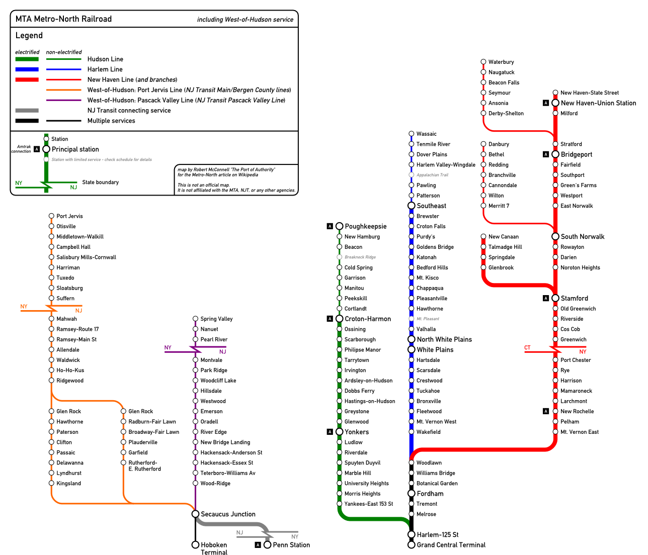
English: Map of the MTA Metro-North Railroad network (including west-of-Hudson service operated by New Jersey Transit) created using Inkscape. This map is not to scale. |
| Date | |
| Source | Own work (Original text: self-made) |
| Author | The Port of Authority (talk) |
Licensing
[edit]
The Port of Authority at English Wikipedia, the copyright holder of this work, hereby publishes it under the following licenses:
This file is licensed under the Creative Commons Attribution-Share Alike 3.0 Unported license.
Attribution: The Port of Authority at English Wikipedia
- You are free:
- to share – to copy, distribute and transmit the work
- to remix – to adapt the work
- Under the following conditions:
- attribution – You must give appropriate credit, provide a link to the license, and indicate if changes were made. You may do so in any reasonable manner, but not in any way that suggests the licensor endorses you or your use.
- share alike – If you remix, transform, or build upon the material, you must distribute your contributions under the same or compatible license as the original.

|
Permission is granted to copy, distribute and/or modify this document under the terms of the GNU Free Documentation License, Version 1.2 or any later version published by the Free Software Foundation; with no Invariant Sections, no Front-Cover Texts, and no Back-Cover Texts. A copy of the license is included in the section entitled GNU Free Documentation License. |
You may select the license of your choice.
Original upload log
[edit]
Transferred from en.wikipedia to Commons by Train2104 using CommonsHelper.
The original description page was here. All following user names refer to en.wikipedia.
- 2009-06-04 03:20 The Port of Authority 1288×1104× (334129 bytes) {{Information |Description = [[Metro-North Railroad]] route map diagram, version 2. Includes the Yankees-East 153rd Street station, as well as the new name for North Hackensack station. Also included [[Amtrak]] connections. |Source = self-mad
- 2009-06-02 14:13 Oknazevad 1288×1104× (261389 bytes) trying one last time to upload revised version!
- 2009-06-02 14:06 Oknazevad 1288×1104× (261389 bytes)
- 2009-06-02 14:03 Oknazevad 1288×1104× (262211 bytes) Reverted to version as of 13:40, 2 June 2009
- 2009-06-02 14:02 Oknazevad 1288×1104× (262211 bytes) trying again
- 2009-06-02 13:40 Oknazevad 1288×1104× (262211 bytes) Updated to reflect opening of Yankees-E 153 St and New Bridge Landing name change.
- 2009-03-01 04:57 The Port of Authority 1288×1104× (326489 bytes) {{Information |Description=Map of the [[MTA Metro-North Railroad]] network, created using Inkscape. |Source=self-made |Date=2009.02.28 |Author=~~~ |other_versions= }}
File history
Click on a date/time to view the file as it appeared at that time.
| Date/Time | Thumbnail | Dimensions | User | Comment | |
|---|---|---|---|---|---|
| current | 00:44, 28 February 2012 | | 1,288 × 1,104 (326 KB) | File Upload Bot (Magnus Manske) (talk | contribs) | {{BotMoveToCommons|en.wikipedia|year={{subst:CURRENTYEAR}}|month={{subst:CURRENTMONTHNAME}}|day={{subst:CURRENTDAY}}}} {{Information |Description={{en|Map of the en:MTA Metro-North Railroad network (including west-of-Hudson service operated by [... |
You cannot overwrite this file.
File usage on Commons
There are no pages that use this file.