File:Meuse Basin.svg
Jump to navigation
Jump to search

Size of this PNG preview of this SVG file: 396 × 600 pixels. Other resolutions: 158 × 240 pixels | 317 × 480 pixels | 507 × 768 pixels | 676 × 1,024 pixels | 1,352 × 2,048 pixels | 660 × 1,000 pixels.
Original file (SVG file, nominally 660 × 1,000 pixels, file size: 227 KB)
Captions
Captions
Add a one-line explanation of what this file represents
Summary[edit]
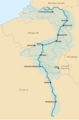
| Description | Map of the Meuse river basin |
| Date | (UTC) |
| Source | |
| Author |
|
| Other versions |
|


| This is a retouched picture, which means that it has been digitally altered from its original version. Modifications: Map translated to English. The original can be viewed here: Bassin de la Meuse.svg:
|
I, the copyright holder of this work, hereby publish it under the following licenses:
| This file is licensed under the Creative Commons Attribution-Share Alike 3.0 Unported license. | ||
| ||
| This licensing tag was added to this file as part of the GFDL licensing update. |

|
Permission is granted to copy, distribute and/or modify this document under the terms of the GNU Free Documentation License, Version 1.2 or any later version published by the Free Software Foundation; with no Invariant Sections, no Front-Cover Texts, and no Back-Cover Texts. A copy of the license is included in the section entitled GNU Free Documentation License. |
You may select the license of your choice.
Original upload log[edit]
This image is a derivative work of the following images:
- File:Stroomgebied van de Maas.svg licensed with Cc-by-sa-3.0-migrated, GFDL
- File:Bassin_de_la_Meuse.svg licensed with Cc-by-sa-3.0-migrated, GFDL
- 2007-01-03T14:46:55Z Nicolas Lardot 660x1000 (329911 Bytes) {{Information |Description=Carte représentant l'importance du Bassin de la Meuse en Wallonie |Source=[[:Image:Meuse basin.jpg]] |Date=3 January 2007 |Author=Own Work, svg and inspired by [[:Image:Meuse basin.jpg]] |Permissio
Uploaded with derivativeFX
File history
Click on a date/time to view the file as it appeared at that time.
| Date/Time | Thumbnail | Dimensions | User | Comment | |
|---|---|---|---|---|---|
| current | 18:29, 22 July 2022 | | 660 × 1,000 (227 KB) | Pseudomonas (talk | contribs) | {{Information |Description=Map of the Meuse river basin |Source=*Bassin_de_la_Meuse.svg |Date=2022-07-22 18:24 (UTC) |Author=*Bassin_de_la_Meuse.svg: Own Work, svg and inspired by Image:Meuse basin.jpg *derivative work: UserːPseudomonas |Permission= |other_versions= <gallery> File:Stroomgebied van de Maas.svg|{{#language:nl}} File:Stroomgebied van de Maas-el.svg|{{#language:el}} File:Bassin de la Meuse.svg|{{#language:fr}}... |
You cannot overwrite this file.
File usage on Commons
The following page uses this file:
File usage on other wikis
The following other wikis use this file:
- Usage on en.wikipedia.org
- Usage on ur.wikipedia.org