File:MiG Alley Map (zh-hans).svg
From Wikimedia Commons, the free media repository
Jump to navigation
Jump to search

Size of this PNG preview of this SVG file: 557 × 599 pixels. Other resolutions: 223 × 240 pixels | 446 × 480 pixels | 714 × 768 pixels | 952 × 1,024 pixels | 1,903 × 2,048 pixels | 696 × 749 pixels.
Original file (SVG file, nominally 696 × 749 pixels, file size: 129 KB)
File information
Structured data
Captions
Captions
Add a one-line explanation of what this file represents
米格走廊
Summary[edit]
| DescriptionMiG Alley Map (zh-hans).svg |
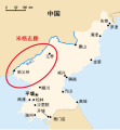
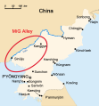
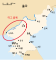
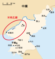
English: The area called "MiG Alley" during the Korean War (1950-53) on the Chinese-North Korean border.
中文(简体):朝鲜战争(1950年—1953年)期间名为「米格走廊」的中朝边境沿线地区
| |||
| Typeface InfoField |
|
|||
| Date | ||||
| Source |
This file was derived from: MiG Alley Map.JPG |
|||
| Author |
|
|||
| Other versions |
|
|||
| SVG development InfoField |
|
Licensing[edit]
| Public domainPublic domainfalsefalse |
| I, the copyright holder of this work, release this work into the public domain. This applies worldwide. In some countries this may not be legally possible; if so: I grant anyone the right to use this work for any purpose, without any conditions, unless such conditions are required by law. |
File history
Click on a date/time to view the file as it appeared at that time.
| Date/Time | Thumbnail | Dimensions | User | Comment | |
|---|---|---|---|---|---|
| current | 21:24, 14 June 2017 |  | 696 × 749 (129 KB) | Howard61313 (talk | contribs) | new |
| 17:13, 14 June 2017 |  | 696 × 749 (130 KB) | Howard61313 (talk | contribs) | new | |
| 17:03, 14 June 2017 |  | 696 × 749 (130 KB) | Howard61313 (talk | contribs) | new | |
| 15:27, 14 June 2017 |  | 696 × 749 (130 KB) | Howard61313 (talk | contribs) | {{Information |Description={{en| The area called "MiG Alley" during the Korean War (1950-53) on the Chinese-North Korean border.}} {{zh-hans|1=朝鲜战争(1950年—1953年)期间称为「米格走廊」的中朝边境沿线地区}} |Source={{Deri... |
You cannot overwrite this file.
File usage on Commons
The following 8 pages use this file:
File usage on other wikis
Metadata
This file contains additional information such as Exif metadata which may have been added by the digital camera, scanner, or software program used to create or digitize it. If the file has been modified from its original state, some details such as the timestamp may not fully reflect those of the original file. The timestamp is only as accurate as the clock in the camera, and it may be completely wrong.
| Width | 696px |
|---|---|
| Height | 749px |


