File:Migriggyangzham Co and Dorsoidong Co.jpg
Jump to navigation
Jump to search

Size of this preview: 800 × 438 pixels. Other resolutions: 320 × 175 pixels | 640 × 351 pixels | 1,040 × 570 pixels.
Original file (1,040 × 570 pixels, file size: 174 KB, MIME type: image/jpeg)
Captions
Captions
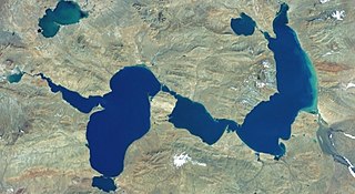
Lakes Migriggyangzham Co (Chibzhang Co) and Dorsoidong Co in west of China
Summary[edit]
| Description |
Русский: Мигриггъянгджам-Цо (к востоку) и Дорсёдонг-Цо (к западу) образуют водную систему. Ранее была известна как Чибчанг или Чибчанг-Цо. Питание от ледников. Небольшое озеро в верхнем левом углу снимка гидрологически никак не связано с этой водной системой, относится к другому водосборному бассейну
English: Lakes Migriggyangzham Co (east, right) and Dorsoidong Co (west, left). |
| Date | Unknown date |
| Source | Screenshot from NASA World Wind software, Blue Marble & Landsat layer |
| Author | NASA |
| Other versions |


| Object location | | View this and other nearby images on: OpenStreetMap |
|---|
Licensing[edit]
| This image is in the public domain because it is a screenshot from NASA’s globe software World Wind using a public domain layer, such as Blue Marble, MODIS, Landsat, SRTM, USGS or GLOBE.
|
 |
File history
Click on a date/time to view the file as it appeared at that time.
| Date/Time | Thumbnail | Dimensions | User | Comment | |
|---|---|---|---|---|---|
| current | 09:37, 17 February 2022 | | 1,040 × 570 (174 KB) | Proeksad (talk | contribs) | Uploaded a work by NASA from Screenshot from NASA World Wind software, Blue Marble & Landsat layer with UploadWizard |
You cannot overwrite this file.
File usage on Commons
The following 2 pages use this file:
File usage on other wikis
The following other wikis use this file:
- Usage on ru.wikipedia.org